IMAGES TAKEN NEAR TO
DRYBROOK, GL17 9AQ
Introduction
This page details the photographs taken nearby to GL17 9AQ by members of the Geograph project.
The Geograph project started in 2005 with the aim of publishing, organising and preserving representative images for every square kilometre of Great Britain, Ireland and the Isle of Man.

There are currently over 7.5m images from over14,400 individuals and you can help contribute to the project by visiting https://www.geograph.org.uk
Image Map (Loading...)


Getting Data...Please wait
Leaflet Map data © OpenStreetMap
Images are licensed for reuse under creativecommons.org/licenses/by-sa/2.0
Notes
- Clicking on the map will re-center to the selected point.
- The higher the marker number, the further away the image location is from the centre of the postcode.
Image Listing (61 Images Found)
Images are licensed for reuse under creativecommons.org/licenses/by-sa/2.0
Image
Details
Distance
2
Boundary Stone, field, Morse Road
Forest of Dean boundary stone in a field in the area described on old maps as The Morse. Looking from Morse Road the stone is maybe 100 yds from the road, ie private land.
Inscription (assumed): D. F. / 1832 / Nᴼ. 133
Milestone Society National ID: GL_DFDRRU133em
Image: © Mr Red
Taken: 4 Feb 2023
0.13 miles
3
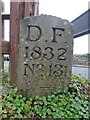
Boundary Stone, Ruardean Hill
Forest of Dean boundary stone at the apex of the junction between Batts Lane and Morse Road. Despit the date on the inscription, this is from a more recent century, probably the 20ᵗʰ.
Inscription: D. F. / 1832 / Nᴼ. 131 / ―
Milestone Society National ID: GL_DFDRYB131em
Image: © Mr Red
Taken: 4 Feb 2023
0.15 miles
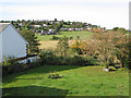
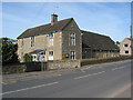
4
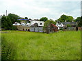
Green space in Drybrook
Drybrook is a typical Forest of Dean village with scattered cottages and small pieces of open ground like this.
In the distance is Overbrook Garage.
Image: © Jonathan Billinger
Taken: 9 Jun 2009
0.16 miles
5
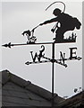
Fisherman weathervane on a Quabbs Road roof, Drybrook
Near the white chimneystack here. http://www.geograph.org.uk/photo/5239888
Image: © Jaggery
Taken: 11 Dec 2016
0.16 miles
6
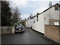
Quabbs Road, Drybrook
Looking WNW from near the Drybrook Road junction.
Image: © Jaggery
Taken: 11 Dec 2016
0.16 miles
7
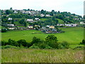
View across the Drybrook valley
Looking west from Trinity Road beyond Morse Road to Ruardean Hill.
Image: © Jonathan Billinger
Taken: 9 Jun 2009
0.16 miles
9
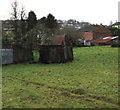
Rusty metal roof buildings, Drybrook
Located between Drybrook Road (on this side) and Quabbs Road.
Image: © Jaggery
Taken: 11 Dec 2016
0.17 miles