IMAGES TAKEN NEAR TO
Dursley Cross, LONGHOPE, GL17 0ND
Introduction
This page details the photographs taken nearby to Dursley Cross, GL17 0ND by members of the Geograph project.
The Geograph project started in 2005 with the aim of publishing, organising and preserving representative images for every square kilometre of Great Britain, Ireland and the Isle of Man.

There are currently over 7.5m images from over14,400 individuals and you can help contribute to the project by visiting https://www.geograph.org.uk
Image Map (Loading...)


Getting Data...Please wait
Leaflet Map data © OpenStreetMap
Images are licensed for reuse under creativecommons.org/licenses/by-sa/2.0
Notes
- Clicking on the map will re-center to the selected point.
- The higher the marker number, the further away the image location is from the centre of the postcode.
Image Listing (42 Images Found)
Images are licensed for reuse under creativecommons.org/licenses/by-sa/2.0
Image
Details
Distance
1
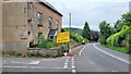
A40 road closure, 1
The Ross end of the closure about to happen from August 2022.
This is to replace a length of collapsing highway.
Image: © Jonathan Billinger
Taken: 23 Jul 2022
0.01 miles
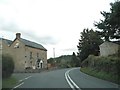
3
A40 at Dursley Cross
The turning to Glasshouse Hill to the left; looking east towards Gloucester in this shot.
Image: © Jonathan Billinger
Taken: 2 Sep 2009
0.01 miles
4
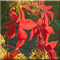
Parthenocissus quinquefolia, Virginia Creeper
The five-lobed leaves are back lit by early October morning sunlight.
The seed heads touched by the golden light are Wild Clematis, Clematis vitalba.
Image: © Jonathan Billinger
Taken: 9 Oct 2020
0.01 miles
5
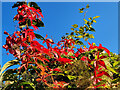
Parthenocissus quinquefolia, Virginia Creeper
Against a brilliant blue October morning sky.
Image: © Jonathan Billinger
Taken: 10 Oct 2021
0.01 miles
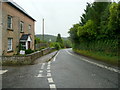
6
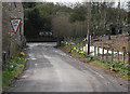
Minor road meets the A40 at Dursley Cross
Left to Gloucester, right to Ross-on-Wye. The chicken has broken through from the field on the right.
Image: © Pauline E
Taken: 14 Mar 2008
0.02 miles
7

Dursley Cross, 1
Looking north towards the A40 junction and Huntley Hill beyond.
Image: © Jonathan Billinger
Taken: 23 May 2019
0.02 miles
8
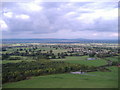
View from Cam Peak towards Ashmead Green.
In the far distance, above Ashmead Green, May Hill can be seen beyond the River Severn.
Image: © Ken Wilkins
Taken: 22 Oct 2005
0.02 miles
9
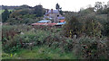
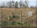
Uncultivated land, 2
At the rear of Mill House, seen here.
Image: © Jonathan Billinger
Taken: 19 Oct 2020
0.02 miles
10
Free range
This field has chickens, ducks, geese, sheep and lambs all getting along just fine.
Image: © Pauline E
Taken: 14 Mar 2008
0.05 miles