IMAGES TAKEN NEAR TO
Plump Hill, MITCHELDEAN, GL17 0EZ
Introduction
This page details the photographs taken nearby to Plump Hill, GL17 0EZ by members of the Geograph project.
The Geograph project started in 2005 with the aim of publishing, organising and preserving representative images for every square kilometre of Great Britain, Ireland and the Isle of Man.

There are currently over 7.5m images from over14,400 individuals and you can help contribute to the project by visiting https://www.geograph.org.uk
Image Map (Loading...)


Getting Data...Please wait
Leaflet Map data © OpenStreetMap
Images are licensed for reuse under creativecommons.org/licenses/by-sa/2.0
Notes
- Clicking on the map will re-center to the selected point.
- The higher the marker number, the further away the image location is from the centre of the postcode.
Image Listing (34 Images Found)
Images are licensed for reuse under creativecommons.org/licenses/by-sa/2.0
Image
Details
Distance
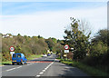
1
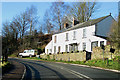
Cottages with a good view
Although positioned by the side of the busy A4136 on Plump Hill, the occupants of these cottages have long-ranging views to the southeast.
Image: © Pauline E
Taken: 18 Jan 2009
0.03 miles
2

Hole in the fence, A4136, Plump Hill
Temporary barriers cover the gap in the fence where a car has gone through. It's a 40 mph zone and it's needed on these sharp hillside bends.
Image: © Pauline E
Taken: 18 Jan 2009
0.06 miles
3
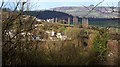
View towards Edge Hill House on Plump Hill
View towards houses on A 4136 on Plump Hill with May Hill in background. Edge Hill House was built circa 1860 and housed the manager of the nearby Edgehills Iron Mine (aka Westbury Brook Iron Mine).
Image: © Clint Mann
Taken: 3 Mar 2012
0.07 miles
4
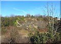
Old Quarry on Plump Hill
This former dolomite quarry is now a nature reserve.
Image: © Des Blenkinsopp
Taken: 6 Feb 2015
0.07 miles
5
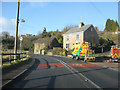
Temporary lights arriving
The highway maintenance team are setting up temporary traffic lights on Plump Hill.
Image: © Pauline E
Taken: 18 Jan 2009
0.09 miles
6
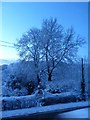
Winter view across the A4136
Taken in early morning on Plump Hill from outside Edgehill House after four inches of snow the previous night. Later on the BBC sent a mobile recording studio and broadcast from 50 yards away reports on the conditions, with mention of the difficulties that lorries had getting up the hill. By the end of the day the snow had all melted. The two large trees are ash and the one to the rear left is a yew.
Image: © Clint Mann
Taken: 14 Jan 2015
0.11 miles
7
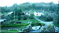
Junction of The Rocks & Hazel Hill with lime kilns
Early spring evening image of junction of The Rocks and Hazel Hill. Image depicts minor roads and tracks, pathways and remains of two lime kilns, with forestry land on hillside beyond.
Image: © Clint Mann
Taken: 16 Mar 2014
0.12 miles
8
A4136 from Edgehill House
Early evening view from Edgehill House on the A4136 that runs from Mitcheldean to Monmouth. View looks across to River Severn and the Cotswold Hills beyond. Photograph was taken with a full moon visible above the horizon.
Image: © Clint Mann
Taken: 14 May 2014
0.12 miles
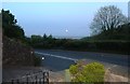
10
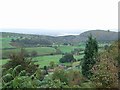
View from Plump Hill
Looking South-East with the River Severn in the background.
Image: © Jennifer Luther Thomas
Taken: 27 Oct 2006
0.13 miles