IMAGES TAKEN NEAR TO
New Road, MITCHELDEAN, GL17 0EP
Introduction
This page details the photographs taken nearby to New Road, GL17 0EP by members of the Geograph project.
The Geograph project started in 2005 with the aim of publishing, organising and preserving representative images for every square kilometre of Great Britain, Ireland and the Isle of Man.

There are currently over 7.5m images from over14,400 individuals and you can help contribute to the project by visiting https://www.geograph.org.uk
Image Map (Loading...)


Getting Data...Please wait
Leaflet Map data © OpenStreetMap
Images are licensed for reuse under creativecommons.org/licenses/by-sa/2.0
Notes
- Clicking on the map will re-center to the selected point.
- The higher the marker number, the further away the image location is from the centre of the postcode.
Image Listing (66 Images Found)
Images are licensed for reuse under creativecommons.org/licenses/by-sa/2.0
Image
Details
Distance
2
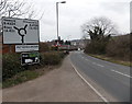
Southern boundary of Mitcheldean
The A4136 passes the boundary sign at the southern edge of Mitcheldean, a small town at the eastern edge of the Forest of Dean in Gloucestershire.
Image: © Jaggery
Taken: 24 Feb 2013
0.03 miles
3
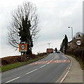
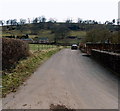
Northern boundary of Plump Hill
The A4136 leaves Mitcheldean and enters Plump Hill, a community in the parish of Abenhall.
Image: © Jaggery
Taken: 24 Feb 2013
0.03 miles
4
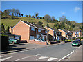
Nourse Place houses, Mitcheldean
The houses are at the SW end of Nourse Place, a separately-named area of houses
alongside the A4136 New Road. The turning on the right is into Baynham Road.
Image: © Jaggery
Taken: 24 Feb 2013
0.04 miles
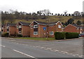
5
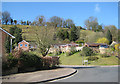
Modern housing, Mitcheldean
This is Baynham Road with the steep sides of Plump Hill behind.
Image: © Pauline E
Taken: 27 Mar 2008
0.05 miles
6
Anns Walk, Mitcheldean
Anns Walk (no apostrophe on the name sign) is a private road
connecting with Baby Lane http://www.geograph.org.uk/photo/3347554 and Silver Street behind the camera.
Image: © Jaggery
Taken: 24 Feb 2013
0.06 miles
7
Hillside houses, Mitcheldean
Also roadside - the lampposts are on the edge of the A4136.
Image: © Pauline E
Taken: 27 Mar 2008
0.06 miles
8
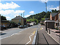
New Road, Mitcheldean
The A4136 to Staunton and Monmouth.
Image: © Pauline E
Taken: 25 Aug 2007
0.07 miles
9
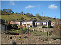
Hillside housing, Mitcheldean
On the slopes of Plump Hill.
Image: © Pauline E
Taken: 27 Mar 2008
0.08 miles
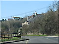
10
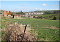
View towards Mitcheldean from Plump Hill
The spire belongs to St. Michael and All Angels Church.
Image: © Pauline E
Taken: 27 Mar 2008
0.08 miles