IMAGES TAKEN NEAR TO
Spout Lane, MITCHELDEAN, GL17 0EA
Introduction
This page details the photographs taken nearby to Spout Lane, GL17 0EA by members of the Geograph project.
The Geograph project started in 2005 with the aim of publishing, organising and preserving representative images for every square kilometre of Great Britain, Ireland and the Isle of Man.

There are currently over 7.5m images from over14,400 individuals and you can help contribute to the project by visiting https://www.geograph.org.uk
Image Map (Loading...)


Getting Data...Please wait
Leaflet Map data © OpenStreetMap
Images are licensed for reuse under creativecommons.org/licenses/by-sa/2.0
Notes
- Clicking on the map will re-center to the selected point.
- The higher the marker number, the further away the image location is from the centre of the postcode.
Image Listing (11 Images Found)
Images are licensed for reuse under creativecommons.org/licenses/by-sa/2.0
Image
Details
Distance
1
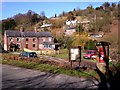
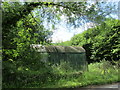
Under wraps
I'm not sure what's being developed behind the sheets of white plastic and scaffolding at Guns Mill, site of a former blast furnace.
Image: © Pauline E
Taken: 23 Mar 2009
0.02 miles
2
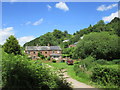
Mill in the Forest - Flaxley, Gloucestershire
This is Gunn's Mill at Flaxley in the Forest of Dean (OS Explorer OL14) as it was in 1988. It was a 17th century charcoal blast furnace and in the following century a paper mill. Time photo taken not available. Source:Historic England. Image
Image: © Martin Richard Phelan
Taken: Unknown
0.05 miles
3
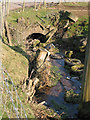
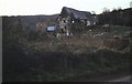
Two tyres, a wheel and a barrel
Whether dumped accidentally or on purpose we will never know. They lie in the stream at the bottom of Welshbury Hill as it passes under the Westbury road.
Image: © Pauline E
Taken: 16 Feb 2008
0.07 miles
4
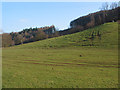
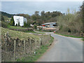
Slopes of Welshbury Hill
Welshbury Hill-fort lies west of Flaxley in Welshbury Woods. It lies on land belonging to the Forestry Commission.
Image: © Pauline E
Taken: 16 Feb 2008
0.13 miles
5
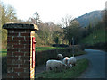
Postbox at Shapridge
With straying sheep.
Image: © Pauline E
Taken: 16 Feb 2008
0.17 miles
6
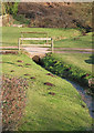
Stream with bridge at Shapridge
Allowing access to cottages.
Image: © Pauline E
Taken: 16 Feb 2008
0.18 miles
8
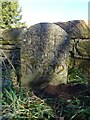
Boundary Stone, Shapridge
A Forest of Dean boundary stone at the left hand end of a bridge parapet on the NE verge of the road. The coping stones of the parapet are at 91.2 m Above Sea Level.
Inscription: D. F. / 2009 / Nᴼ. 192
Milestone Society National ID: GL_DFLIMI192em
Image: © Mr Red
Taken: 7 Feb 2023
0.19 miles