IMAGES TAKEN NEAR TO
Hawkers Hill, MITCHELDEAN, GL17 0BS
Introduction
This page details the photographs taken nearby to Hawkers Hill, GL17 0BS by members of the Geograph project.
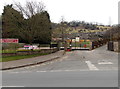
The Geograph project started in 2005 with the aim of publishing, organising and preserving representative images for every square kilometre of Great Britain, Ireland and the Isle of Man.

There are currently over 7.5m images from over14,400 individuals and you can help contribute to the project by visiting https://www.geograph.org.uk
Image Map (Loading...)


Getting Data...Please wait
Leaflet Map data © OpenStreetMap
Images are licensed for reuse under creativecommons.org/licenses/by-sa/2.0
Notes
- Clicking on the map will re-center to the selected point.
- The higher the marker number, the further away the image location is from the centre of the postcode.
Image Listing (137 Images Found)
Images are licensed for reuse under creativecommons.org/licenses/by-sa/2.0
Image
Details
Distance
1
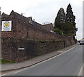
Sunbeams Day Nursery, Mitcheldean
Viewed across the B4224 Hawker Hill. Sunbeams Day Nursery, for children of pre-school age,
is in the refurbished and re-equipped former primary school building.
Image: © Jaggery
Taken: 24 Feb 2013
0.01 miles
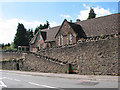
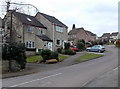
2
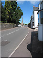
Hawker Hill, Mitcheldean
A short stretch of the B4224, leading to a stretch of similar length called Stars Pitch, and then the High Street.
Image: © Pauline E
Taken: 25 Aug 2007
0.02 miles
3
Former primary school in Mitcheldean
Viewed across the B4224 Hawker Hill. The refurbished and re-equipped former
primary school building houses Sunbeams Day Nursery, for children of pre-school age.
Image: © Jaggery
Taken: 24 Feb 2013
0.03 miles
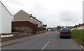
4
Southern end of Hawker Hill, Mitcheldean
Looking north across the A4136 along the B4224, which has three names ahead.
The B4224 Hawker Hill becomes the B4224 Stars Pitch and then the B4224 High Street.
Image: © Jaggery
Taken: 24 Feb 2013
0.04 miles
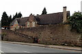
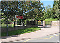
5
Entrance to Mitcheldean Endowed C of E Primary School
The school http://www.geograph.org.uk/photo/3833136 is on the west side of the B4224 Hawker Hill in Mitcheldean, a small town in the Forest of Dean, Gloucestershire.
Image: © Jaggery
Taken: 24 Feb 2013
0.04 miles
6
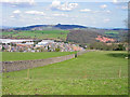
View towards May Hill from the Wilderness Centre
This view includes 1) May Hill identified by the group of Fir trees on the top of the hill. 2) The factory buildings of the former Rank Xerox factory which is now a Business Park. 3) The red scar showing where the stone has been quarried and taking the name of Wilderness Quarry.
Image: © charlie rigby
Taken: 8 Apr 2010
0.04 miles
7
Day Nursery, Hawker Hill, Mitcheldean
Sited in a Victorian building which was the former primary school.
Image: © Pauline E
Taken: 25 Aug 2007
0.04 miles
8
Entrance to Mitcheldean Endowed C of E Primary School
Replacing an older building in Merrin Street. With great views up a steep hillside, with woodland at the top.
Image: © Pauline E
Taken: 25 Aug 2007
0.05 miles
9
Dean Meadows, Mitcheldean
Viewed from the corner of the A4136 Gloucester Road. Dean Meadows is a cul-de-sac of about 60 houses.
Image: © Jaggery
Taken: 24 Feb 2013
0.05 miles
10
Eastern Avenue, Mitcheldean
Looking ENE from the B4224 end. Eastern Avenue leads to Bull Ring and Parks Road.
Image: © Jaggery
Taken: 24 Feb 2013
0.05 miles