IMAGES TAKEN NEAR TO
Blaisdon, LONGHOPE, GL17 0AJ
Introduction
This page details the photographs taken nearby to GL17 0AJ by members of the Geograph project.
The Geograph project started in 2005 with the aim of publishing, organising and preserving representative images for every square kilometre of Great Britain, Ireland and the Isle of Man.

There are currently over 7.5m images from over14,400 individuals and you can help contribute to the project by visiting https://www.geograph.org.uk
Image Map (Loading...)


Getting Data...Please wait
Leaflet Map data © OpenStreetMap
Images are licensed for reuse under creativecommons.org/licenses/by-sa/2.0
Notes
- Clicking on the map will re-center to the selected point.
- The higher the marker number, the further away the image location is from the centre of the postcode.
Image Listing (16 Images Found)
Images are licensed for reuse under creativecommons.org/licenses/by-sa/2.0
Image
Details
Distance
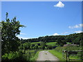
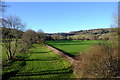
2
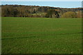
View towards Blaisdon Hill
The edge of the Forest of Dean.
Image: © Jonathan Thacker
Taken: 15 Jun 2017
0.07 miles
3
Entrance to Monk Hill Farm
Monk Hill Farm with Muggleswort Wood in the background.
Image: © Philip Halling
Taken: 13 Nov 2010
0.08 miles
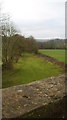
4
Entrance to Monk Hill Farm
Looking west from the lane to Flaxley with Mugglewort Wood beyond.
An old cider orchard to the left.
Image: © Jonathan Billinger
Taken: 29 Sep 2009
0.09 miles
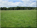
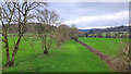
5
View to Blaisdon Hall
View across farmland to Blaisdon Hall from near the entrance to Monk Hill Farm.
Image: © Philip Halling
Taken: 13 Nov 2010
0.10 miles
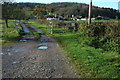
6
Site of Blaisdon Halt
Seen looking east from the intact road bridge, this was the first stop on the Gloucester - Hereford line after the junction at Grange Court. The halt closed, along with the end of passenger services on the line on 31st October 1964.
Image: © David Stowell
Taken: 2 Oct 2005
0.12 miles
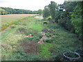
7
Railway trackbed at Blaisdon
The remains of the Hereford, Ross and Gloucester railway at Blaisdon Halt, looking north-west.
Image: © Jonathan Billinger
Taken: 7 Feb 2024
0.14 miles
8
Dismantled Railway near Blaisdon
The view heading toward Ross.
Image: © David Robinson
Taken: 22 Dec 2008
0.14 miles
9
Railway to Ross and beyond
A view along the old trackbed to Ross on Wye and Hereford. The next station along the line was Longhope, just on the other side of the hill in the right background.
Image: © John Winder
Taken: 7 Jan 2018
0.14 miles
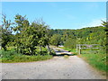
10
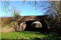
Bridge at Blaisdon
A better shot of the bridge featured in my shot Image] which carries a minor road over the trackbed of the Gloucester - Hereford line at Blaisdon. Taken from a footpath which crosses the old trackbed.
Image: © John Winder
Taken: 7 Jan 2018
0.15 miles