IMAGES TAKEN NEAR TO
Velthouse Lane, LONGHOPE, GL17 0AD
Introduction
This page details the photographs taken nearby to Velthouse Lane, GL17 0AD by members of the Geograph project.
The Geograph project started in 2005 with the aim of publishing, organising and preserving representative images for every square kilometre of Great Britain, Ireland and the Isle of Man.

There are currently over 7.5m images from over14,400 individuals and you can help contribute to the project by visiting https://www.geograph.org.uk
Image Map
Images are licensed for reuse under creativecommons.org/licenses/by-sa/2.0
Notes
- Clicking on the map will re-center to the selected point.
- The higher the marker number, the further away the image location is from the centre of the postcode.
Image Listing (8 Images Found)
Images are licensed for reuse under creativecommons.org/licenses/by-sa/2.0
Image
Details
Distance
1
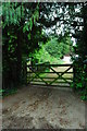
Course of old railway near Longhope
Here's where the railway ran towards Longhope. The gateposts, and possibly even the gate, appear to date back to when the railway was active. There was a level crossing here which carried the railway across a farm track.
After taking this, I was approached by a chap who looked like the stereotypical Gloucestershire farmer. He looked a bit suspicious and told me he was from the Neighbourhood Watch scheme, so I hastened to reassure him by telling him I was photographing the remains of the railway. It was as if I had opened some floodgates! He told me how he remembered the railway being operational, and using it to go on his holidays as a child, and if I got a chance I should go and photograph Doctor Beeching's grave and maybe dance on it, and so on and on and on. It's always nice to meet another railway enthusiast, but I thought I'd never get away from this one!
Image: © John Winder
Taken: 2 May 2014
0.03 miles
4

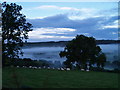
Post-sunset sky
Looking west from Longhope across to the wooded crest of Pool Hill at 17.53 on 10th February 2023.
Image: © Jonathan Billinger
Taken: 10 Feb 2023
0.21 miles
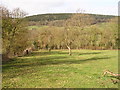
6
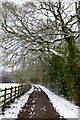
Snowy beech trees
Over the track to Blaisdon Wood.
Image: © David Lally
Taken: 23 Mar 2013
0.22 miles
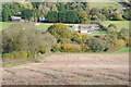
7
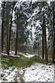
Blaisdon Wood
Which turns-out to be a pine plantation.
Image: © David Lally
Taken: 23 Mar 2013
0.22 miles
