IMAGES TAKEN NEAR TO
Crucible Close, COLEFORD, GL16 8PS
Introduction
This page details the photographs taken nearby to Crucible Close, GL16 8PS by members of the Geograph project.
The Geograph project started in 2005 with the aim of publishing, organising and preserving representative images for every square kilometre of Great Britain, Ireland and the Isle of Man.

There are currently over 7.5m images from over14,400 individuals and you can help contribute to the project by visiting https://www.geograph.org.uk
Image Map (49 Images)


Leaflet Map data © OpenStreetMap
Images are licensed for reuse under creativecommons.org/licenses/by-sa/2.0
Notes
- Clicking on the map will re-center to the selected point.
- The higher the marker number, the further away the image location is from the centre of the postcode.
Image Listing (49 Images Found)
Images are licensed for reuse under creativecommons.org/licenses/by-sa/2.0
Image
Details
Distance
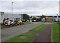
1
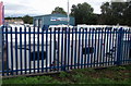
Coleford Leisure, Coleford
Caravan and motorhome sales and service business set back from the east side of Old Station Way.
Image: © Jaggery
Taken: 4 Sep 2016
0.01 miles
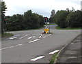
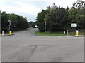
2
Northern entrance to the Forest of Dean Business Estate, Coleford
Viewed across the B4228. A sign on the left points right
along Tufthorn Avenue towards the business estate.
Image: © Jaggery
Taken: 12 Dec 2011
0.02 miles
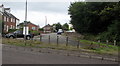
3

Pete Smith car sales, Coleford
Located on the corner of Old Station Way and Crucible Close.
Image: © Jaggery
Taken: 4 Sep 2016
0.05 miles
4
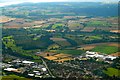
High Nash Cross Roads
Beechams Factory on the right hand side.
Image: © Peter Randall-Cook
Taken: 3 Aug 2007
0.05 miles
5
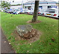
Plaque recording the official opening of Mushet Industrial Park, Coleford
The Forest of Dean Council metal plaque embedded in a boulder on the east side of Old Station Way records that Mushet Industrial Park was officially opened on July 29th 1986 by Lord Vinson, chairman of the development commission.
Image: © Jaggery
Taken: 4 Sep 2016
0.05 miles
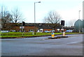
6
Traffic lights at crossroads in Coleford
Viewed from Tufthorn Avenue which crosses the B4228 Old Station Way ahead.
Image: © Jaggery
Taken: 4 Sep 2016
0.05 miles
7
Blocked-off eastern end of High Nash, Coleford
Viewed across Old Station Way.
Image: © Jaggery
Taken: 4 Sep 2016
0.06 miles
8
Crucible Close, Coleford
A road through Mushet Industrial Park, viewed from the corner of Old Station Way.
Image: © Jaggery
Taken: 4 Sep 2016
0.06 miles
9
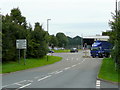
Tufthorn Avenue, Coleford
Looking east towards the crossroads with the B4228.
The blue lorry is probably on its way to the GSK Plant, see Image
Image: © Jonathan Billinger
Taken: 6 Aug 2009
0.06 miles
10
Junction of Tufthorn Avenue and Old Station Way, Coleford
The sign alongside the B4228 Old Station Way on the right shows ½ (mile) to the town centre,
7 to Monmouth, 13 to Ross-on-Wye and 21 to Gloucester.
Image: © Jaggery
Taken: 4 Sep 2016
0.07 miles