IMAGES TAKEN NEAR TO
Rock Lane, COLEFORD, GL16 8HP
Introduction
This page details the photographs taken nearby to Rock Lane, GL16 8HP by members of the Geograph project.
The Geograph project started in 2005 with the aim of publishing, organising and preserving representative images for every square kilometre of Great Britain, Ireland and the Isle of Man.

There are currently over 7.5m images from over14,400 individuals and you can help contribute to the project by visiting https://www.geograph.org.uk
Image Map (Loading...)


Getting Data...Please wait
Leaflet Map data © OpenStreetMap
Images are licensed for reuse under creativecommons.org/licenses/by-sa/2.0
Notes
- Clicking on the map will re-center to the selected point.
- The higher the marker number, the further away the image location is from the centre of the postcode.
Image Listing (50 Images Found)
Images are licensed for reuse under creativecommons.org/licenses/by-sa/2.0
Image
Details
Distance
1
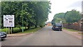
Road approaching the Lucozade Ribena Suntory factory
Image: © Helen Steed
Taken: 4 Aug 2019
0.04 miles
2
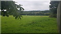
Sheep grazing in a field by the Lucozade Ribena Suntory factory
Image: © Helen Steed
Taken: 4 Aug 2019
0.07 miles
3
St. Margaret Mary catholic church, Coleford.
Situated on High Nash, to the south of the town centre.
Image: © Jonathan Billinger
Taken: 6 Aug 2009
0.09 miles
4
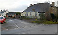
Houses at the southern end of High Nash, Coleford
Viewed from the corner of Rock Lane.
Image: © Jaggery
Taken: 12 Dec 2011
0.09 miles
5
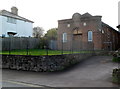
St Margaret Mary's Roman Catholic Church, Coleford
Located on the west side of High Nash. This is one of four RC churches in the Forest of Dean area.
Image: © Jaggery
Taken: 12 Dec 2011
0.09 miles
6

GSK Royal Forest Factory, Coleford
The Ribena and Lucozade bottling plant is a major employer in the Forest of Dean.
Viewed from Tufthorn Avenue.
Image: © Jonathan Billinger
Taken: 6 Aug 2009
0.10 miles
7
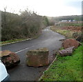
Boulders block access to Perrygrove Road, Coleford
Though it would be apt if this were Rock Lane (which is nearby), this is the northern end
of Perrygrove Road, a few metres from the Tufthorn Avenue junction.
Image: © Jaggery
Taken: 12 Dec 2011
0.10 miles
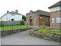
8
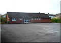
St Margaret Mary's church hall, Coleford
The 25 metre long hall is set back from High Nash, on the north side of the church. http://www.geograph.org.uk/photo/3259267
Image: © Jaggery
Taken: 12 Dec 2011
0.10 miles
9

Foundation stone at the Lucozade Ribena Suntory factory
Dr Vernon Charley (1906-76) was born in Blakeney Image and studied Chemistry at Bristol University. Whilst working at the university's agriculture and horticulture research station at Long Ashton, he was regularly "borrowed" by the neighbouring soft drinks company H W Carter & Co. For them he developed the blackcurrant cordial launched as Ribena in 1938. He was probably instrumental in the choice of Coleford, in his native forest, as the site of Carter's new factory for Ribena after World War Two. H W Carter was bought by the Beecham group in 1955, subsequently becoming part of GlaxoSmithKline who sold the brand to Suntory of Japan in 2013. The site still makes Ribena and now Lucozade too.
Vernon Charley was a Baptist lay preacher, organist and often a source of spontaneous fun to those around him. One of his two children was my mother, Gillian (1934-2017).
Image: © Rosie Hodson
Taken: 22 Mar 2017
0.11 miles
10
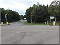
Junction of Tufthorn Avenue and Old Station Way, Coleford
The sign alongside the B4228 Old Station Way on the right shows ½ (mile) to the town centre,
7 to Monmouth, 13 to Ross-on-Wye and 21 to Gloucester.
Image: © Jaggery
Taken: 4 Sep 2016
0.12 miles