IMAGES TAKEN NEAR TO
Sion Place, GL16 8FL
Introduction
This page details the photographs taken nearby to Sion Place, GL16 8FL by members of the Geograph project.
The Geograph project started in 2005 with the aim of publishing, organising and preserving representative images for every square kilometre of Great Britain, Ireland and the Isle of Man.

There are currently over 7.5m images from over14,400 individuals and you can help contribute to the project by visiting https://www.geograph.org.uk
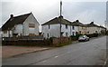
Image Map
Images are licensed for reuse under creativecommons.org/licenses/by-sa/2.0
Notes
- Clicking on the map will re-center to the selected point.
- The higher the marker number, the further away the image location is from the centre of the postcode.
Image Listing (73 Images Found)
Images are licensed for reuse under creativecommons.org/licenses/by-sa/2.0
Image
Details
Distance
1
Hanson Formpave premises, Coleford
Viewed from Tufthorn Avenue. Hanson Formpave is part of Hanson UK, a major supplier of heavy building materials to the UK construction industry. Among the products developed by Hanson Formpave are highly skid-resistant blocks and paving manufactured from gritstone.
Image: © Jaggery
Taken: 12 Dec 2011
0.05 miles
2

Former Sonoco premises, Coleford
The boarded-up and long derelict building is alongside Tufthorn Avenue.
The former cardboard tubing factory closed down in 2009. A local newspaper reported that a major factor leading to closure was the loss of a contract for making Scotch Tape rolls for 3M.
Image: © Jaggery
Taken: 12 Dec 2011
0.05 miles
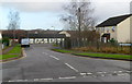
3
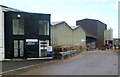
Gate 1, Forest of Dean Business Estate, Coleford
Viewed from the edge of Tufthorn Avenue. A number on the wall shows that this is Unit 10.
Image: © Jaggery
Taken: 12 Dec 2011
0.06 miles
4

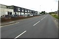
Tufthorne Avenue, Coleford
View north, towards Coleford.
Image: © Alan Hughes
Taken: 12 Dec 2021
0.08 miles
5
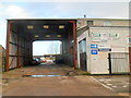
Units on Tufthorn Industrial Estate
Units on Tufthorn Industrial Estate viewed from Tufthorn Avenue near Coleford.
Image: © Philip Halling
Taken: 10 Aug 2017
0.08 miles
6
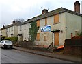
Houses earmarked for demolition on the west side of Tufthorn Avenue, Coleford
The houses with boarded-up windows are some of those to be demolished as part of the Two Rivers Housing Association's community regeneration project in Tufthorn Avenue.
House builders Lovell will construct the replacements.
Image: © Jaggery
Taken: 12 Dec 2011
0.09 miles
7
Houses earmarked for demolition on the east side of Tufthorn Avenue, Coleford
The houses with boarded-up windows are some of those to be demolished as part of the Two Rivers Housing Association's community regeneration project in Tufthorn Avenue.
House builders Lovell will construct the replacements.
Image: © Jaggery
Taken: 12 Dec 2011
0.09 miles
8
Tufthorn Close, Coleford
Viewed across Tufthorn Avenue.
Image: © Jaggery
Taken: 12 Dec 2011
0.10 miles
9
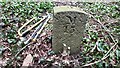
Gale Stone, Perrygrove, Forest of Dean
A "Royal Forest" iron mining rights marker allocated by the "Verderers Court" probably in 1834.
This is on private land, part of the visitor attraction of a narrow gauge railway https://www.perrygrove.co.uk/ . Location is approximate.
Inscription: M / 15
Image: © Michael Crofts
Taken: 1 Mar 2021
0.12 miles
10
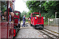
Perrygrove Railway
The drivers of steam locomotive 'Spirit of Adventure' and diesel 'Jubilee' exchange single-line tokens in the passing loop at the Perrygrove Railway.
Image: © Gareth James
Taken: 19 Jun 2022
0.13 miles