1
Junction of Tufthorn Avenue and Old Station Way, Coleford
The sign alongside the B4228 Old Station Way on the right shows ½ (mile) to the town centre,
7 to Monmouth, 13 to Ross-on-Wye and 21 to Gloucester.
Image: © Jaggery
Taken: 4 Sep 2016
0.01 miles
2
Tufthorn Avenue, Coleford
Looking east towards the crossroads with the B4228.
The blue lorry is probably on its way to the GSK Plant, see
Image
Image: © Jonathan Billinger
Taken: 6 Aug 2009
0.03 miles
3
Houses at the southern end of High Nash, Coleford
Viewed from the corner of Rock Lane.
Image: © Jaggery
Taken: 12 Dec 2011
0.03 miles
4
Blocked-off eastern end of High Nash, Coleford
Viewed across Old Station Way.
Image: © Jaggery
Taken: 4 Sep 2016
0.03 miles
5
High Nash Cross Roads
Beechams Factory on the right hand side.
Image: © Peter Randall-Cook
Taken: 3 Aug 2007
0.03 miles
6
Traffic lights at crossroads in Coleford
Viewed from Tufthorn Avenue which crosses the B4228 Old Station Way ahead.
Image: © Jaggery
Taken: 4 Sep 2016
0.03 miles
7
Northern end of Arthur Cooper Way, Coleford
At the Tufthorn Avenue crossroads, the B4228 Old Station Way to the north
becomes the B4228 Arthur Cooper Way to south. It's 6 miles to Lydney and 12 to Chepstow.
Image: © Jaggery
Taken: 12 Dec 2011
0.04 miles
8
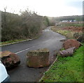
Boulders block access to Perrygrove Road, Coleford
Though it would be apt if this were Rock Lane (which is nearby), this is the northern end
of Perrygrove Road, a few metres from the Tufthorn Avenue junction.
Image: © Jaggery
Taken: 12 Dec 2011
0.04 miles
9
Plaque recording the official opening of Mushet Industrial Park, Coleford
The Forest of Dean Council metal plaque embedded in a boulder on the east side of Old Station Way records that Mushet Industrial Park was officially opened on July 29th 1986 by Lord Vinson, chairman of the development commission.
Image: © Jaggery
Taken: 4 Sep 2016
0.05 miles
10
Northern entrance to the Forest of Dean Business Estate, Coleford
Viewed across the B4228. A sign on the left points right
along Tufthorn Avenue towards the business estate.
Image: © Jaggery
Taken: 12 Dec 2011
0.06 miles


