IMAGES TAKEN NEAR TO
Buchanan Close, COLEFORD, GL16 8EG
Introduction
This page details the photographs taken nearby to Buchanan Close, GL16 8EG by members of the Geograph project.
The Geograph project started in 2005 with the aim of publishing, organising and preserving representative images for every square kilometre of Great Britain, Ireland and the Isle of Man.

There are currently over 7.5m images from over14,400 individuals and you can help contribute to the project by visiting https://www.geograph.org.uk
Image Map (Loading...)


Getting Data...Please wait
Leaflet Map data © OpenStreetMap
Images are licensed for reuse under creativecommons.org/licenses/by-sa/2.0
Notes
- Clicking on the map will re-center to the selected point.
- The higher the marker number, the further away the image location is from the centre of the postcode.
Image Listing (37 Images Found)
Images are licensed for reuse under creativecommons.org/licenses/by-sa/2.0
Image
Details
Distance
1
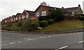
Lark Rise bungalows, Coleford
Bungalows on the north side of Lark Rise, viewed across The Gorse.
Image: © Jaggery
Taken: 23 Nov 2014
0.05 miles
2
Bench on a suburban corner in Coleford
Viewed across The Gorse towards the corner of Buchanan Avenue.
Image: © Jaggery
Taken: 23 Nov 2014
0.05 miles
3
Entrance drive to Great Oaks Hospice, Coleford
On each side of the drive, signs similar to street name signs show GREAT OAKS HOSPICE.
Viewed from the main road, The Gorse.
Image: © Jaggery
Taken: 23 Nov 2014
0.06 miles
4
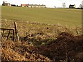
View near Berry Hill
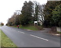
Looking across a field from close to the spot where Image was taken, with Gorse Bungalows along the hilltop road between Berry Hill and Coleford.
Image: © Derek Harper
Taken: 2 Feb 2010
0.08 miles
5
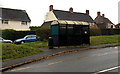
Bus shelter and litter bin, The Gorse, Coleford
Located between The Gorse (the main road) on this side and houses in Sunnybank Road.
Image: © Jaggery
Taken: 23 Nov 2014
0.10 miles
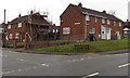
6
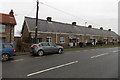
Gorse Bungalows, Coleford
Viewed across The Gorse. The 50 metre long row has 10 houses and 5 front doors. Each doorway has a different house number on each side. Presumably behind each street door there is an entrance hall leading to the two house doors.
Image: © Jaggery
Taken: 23 Nov 2014
0.10 miles
7
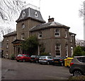
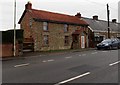
The Coombs, Coleford
Set back from The Gorse, Grade II listed The Coombs was built c1859
as a residence for the Trotter family of Coleford. It is now a care home.
Image: © Jaggery
Taken: 23 Nov 2014
0.10 miles
8
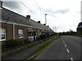
Gorse bungalows, Coleford
A row of almshouses built at the end of the 19th century. They were built as free housing for 5 men and 5 women living within 2 miles of Coleford Baptists Church.
Image: © Eirian Evans
Taken: 17 Sep 2015
0.11 miles
9
Entrance to The Coombs, Coleford
From The Gorse. The Coombs care home http://www.geograph.org.uk/photo/4258412 is Grade II listed.
Image: © Jaggery
Taken: 23 Nov 2014
0.12 miles
10
Little Gorse House, Coleford
Viewed across The Gorse in the north of Coleford. Gorse Bungalows http://www.geograph.org.uk/photo/4258434 are on the right.
Image: © Jaggery
Taken: 23 Nov 2014
0.13 miles