IMAGES TAKEN NEAR TO
Primrose Drive, COLEFORD, GL16 7PU
Introduction
This page details the photographs taken nearby to Primrose Drive, GL16 7PU by members of the Geograph project.
The Geograph project started in 2005 with the aim of publishing, organising and preserving representative images for every square kilometre of Great Britain, Ireland and the Isle of Man.

There are currently over 7.5m images from over14,400 individuals and you can help contribute to the project by visiting https://www.geograph.org.uk
Image Map
Images are licensed for reuse under creativecommons.org/licenses/by-sa/2.0
Notes
- Clicking on the map will re-center to the selected point.
- The higher the marker number, the further away the image location is from the centre of the postcode.
Image Listing (73 Images Found)
Images are licensed for reuse under creativecommons.org/licenses/by-sa/2.0
Image
Details
Distance
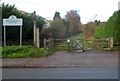
1
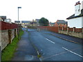
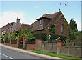
Primrose Drive, Milkwall
Viewed from the Station Road end. In the middle distance, posts mark the location of a cattle grid across the road. Primrose Drive is a cul-de-sac with branches to four short cul-de-sacs,
Bluebell Close, Clover Close, Foxglove Way and Bramble Road.
Image: © Jaggery
Taken: 12 Dec 2011
0.09 miles
2
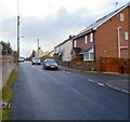
Forest Road, Milkwall
View from the Station Road end.
Image: © Jaggery
Taken: 12 Dec 2011
0.10 miles
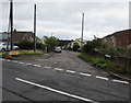
3
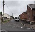
Forest Road, Milkwall, Coleford
Forest Road ascends from Station Road towards Edenwall Road.
Image: © Jaggery
Taken: 4 Sep 2016
0.10 miles
4
Edenwall Road, Milkwall
A dead-end road leading to a footpath across the golf course on Palmer's Flat.
Image: © Jonathan Billinger
Taken: 11 Jun 2010
0.10 miles
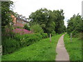
5
Milkwall side of the cycle track to Coleford
Viewed across Station Road from near the site of the former Milkwall railway station. Because they mostly have gentle, if any, inclines, the routes of dismantled railways are a good and frequently used choice for cycle tracks, as here.
Image: © Jaggery
Taken: 12 Dec 2011
0.11 miles
6
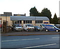
Stepbridge Van Sales, Milkwall
Stepbridge Van Sales & vehicle services is located in Nash & Cox Yard on the north side of Station Road.
Image: © Jaggery
Taken: 12 Dec 2011
0.11 miles
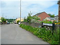
7
Edenwall Road, Milkwall
Dead-end road extending for 265 metres from the northeast side of Tufthorn Road.
Image: © Jaggery
Taken: 4 Sep 2016
0.11 miles
9
House in Station Road - former church
Old St Luke's Church is the name of the house, but apart from the cross on the roof, the house doesn't look much like a church. Built in 1935 and designed by William Leah.
Image: © Pauline E
Taken: 12 Jun 2008
0.11 miles
10
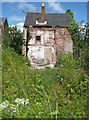
In need of some TLC
Property in Station Road, Milkwall looking very neglected. It appears to have been re-roofed at some point.
Image: © Pauline E
Taken: 12 Jun 2008
0.12 miles