IMAGES TAKEN NEAR TO
Ellwood, COLEFORD, GL16 7LY
Introduction
This page details the photographs taken nearby to GL16 7LY by members of the Geograph project.
The Geograph project started in 2005 with the aim of publishing, organising and preserving representative images for every square kilometre of Great Britain, Ireland and the Isle of Man.

There are currently over 7.5m images from over14,400 individuals and you can help contribute to the project by visiting https://www.geograph.org.uk
Image Map
Images are licensed for reuse under creativecommons.org/licenses/by-sa/2.0
Notes
- Clicking on the map will re-center to the selected point.
- The higher the marker number, the further away the image location is from the centre of the postcode.
Image Listing (34 Images Found)
Images are licensed for reuse under creativecommons.org/licenses/by-sa/2.0
Image
Details
Distance
1
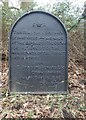
NEW
Road Improvement Plaque, Ellwood
A cast iron plate describing the Edwardian metalling of Ellwood Road and Bromley Road from Milkwall to Ellwood.
The plate has been re-inforced. There is a companion plaque in Milkwall Image
Inscription:
E (crown) R
This road for the distance
of 11485 ↣ yards was made
at the expense of the crown
for the benefit of the
inhabitants and district
1906
E.Stafford Howard Esq
Commissioner
Philip Baylis Esq
Dep Sur
Milestone Society National ID: tbc
Image: © Mr Red
Taken: 11 Mar 2025
0.05 miles
2
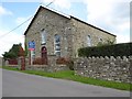
Former Methodist chapel
Former Methodist chapel in Ellwood which is currently for sale for conversion.
Image: © Philip Halling
Taken: 10 Aug 2017
0.06 miles
3
Ellwood Methodist church, Ellwood
Viewed across Bromley Road in the Forest of Dean District of west Gloucestershire.
The church is opposite Ellwood Community Primary School. http://www.geograph.org.uk/photo/4560105
Image: © Jaggery
Taken: 5 Jul 2015
0.06 miles
4
Ellwood Methodist church and churchyard, Ellwood
On the NE side of Bromley Road, opposite Ellwood Community Primary School. http://www.geograph.org.uk/photo/4560105
Image: © Jaggery
Taken: 5 Jul 2015
0.06 miles
5
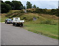
Track to a mound, Ellwood
From Bromley Road in the Forest of Dean District of west Gloucestershire.
Image: © Jaggery
Taken: 5 Jul 2015
0.06 miles
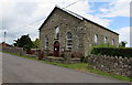
6
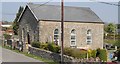
Ellwood Methodist Chapel
Ellwood Primitive Methodist Chapel was built in 1873. It is currently being converted for residential use. The burial ground is still in use. This is one of my churches and chapels series - which I have visited from home by bike.
Image: © Andy Stott
Taken: 26 Apr 2020
0.06 miles
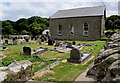
7
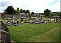
Ellwood Methodist churchyard, Ellwood
On the west side of the church. http://www.geograph.org.uk/photo/4560088
Image: © Jaggery
Taken: 5 Jul 2015
0.06 miles
8
Ellwood Nursery, Ellwood
Located in the Old School House, Bromley Road, in the NE corner of Ellwood Community Primary School.
The private nursery is for pre-school children aged 2-5.
Image: © Jaggery
Taken: 5 Jul 2015
0.07 miles
9

Church and school, Bromley Road, Ellwood
Ellwood Methodist church on the left, Ellwood Community Primary School on the right.
Image: © Jaggery
Taken: 5 Jul 2015
0.07 miles
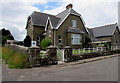
10
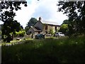
Cottages at Ellwood
Cottages in Ellwood, a small hamlet in the Forest of Dean.
Image: © Philip Halling
Taken: 10 Aug 2017
0.09 miles