IMAGES TAKEN NEAR TO
Wynols Hill, COLEFORD, GL16 7JB
Introduction
This page details the photographs taken nearby to Wynols Hill, GL16 7JB by members of the Geograph project.
The Geograph project started in 2005 with the aim of publishing, organising and preserving representative images for every square kilometre of Great Britain, Ireland and the Isle of Man.

There are currently over 7.5m images from over14,400 individuals and you can help contribute to the project by visiting https://www.geograph.org.uk
Image Map (Loading...)


Getting Data...Please wait
Leaflet Map data © OpenStreetMap
Images are licensed for reuse under creativecommons.org/licenses/by-sa/2.0
Notes
- Clicking on the map will re-center to the selected point.
- The higher the marker number, the further away the image location is from the centre of the postcode.
Image Listing (33 Images Found)
Images are licensed for reuse under creativecommons.org/licenses/by-sa/2.0
Image
Details
Distance
1
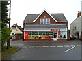
Spar, Coalway
New Road shop viewed from Old Road. The premises were formerly a Nisa Local shop.
Image: © Jaggery
Taken: 11 Dec 2011
0.03 miles
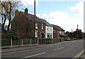
2
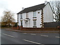
An Edwardian house, New Road, Coalway
The date stone shows the year 1903.
Image: © Jaggery
Taken: 11 Dec 2011
0.09 miles
3
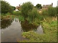
Jugshole Pool
A small pool at the edge of the Forest beside Bixhead Walk (in the rear), between Coalway and Broadwell.
Image: © Derek Harper
Taken: 12 Sep 2008
0.09 miles
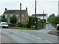
4
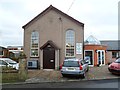
Coalway Methodist Pisgah Chapel
Viewed across Old Road, Coalway. The chapel is part of the Bristol District of The Methodist Church.
The small extension on the right shows the year 2009.
Image: © Jaggery
Taken: 11 Dec 2011
0.12 miles
5
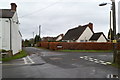
The Purples, Coalway
Viewed from Old Road. The street name sign at the edge of the hedge shows The Purples.
Image: © Jaggery
Taken: 11 Dec 2011
0.15 miles
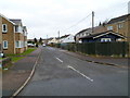
7
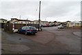
Coalway Park houses, Coalway
Viewed from New Road. Coalway Park contains several dozen park homes, which are modern, bungalow-style residential properties, sometimes referred to as mobile homes.
Image: © Jaggery
Taken: 11 Dec 2011
0.17 miles
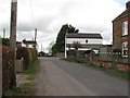
8
New Road and Old Road, Coalway
As indicated by the signage, the Methodist Chapel is along Old Road, to the right.
Image: © Jonathan Billinger
Taken: 6 Jun 2009
0.17 miles
9
Holcot Road, Coleford
Viewed from the Coalway Road end. Holcot Road is a few tens of metres
on the Coleford side of the boundary with Coalway.
Image: © Jaggery
Taken: 11 Dec 2011
0.18 miles
10
Ernest Heal & Sons, Funeral Directors, Broadwell
Located in South Road.
Image: © Pauline E
Taken: 11 Apr 2008
0.19 miles