IMAGES TAKEN NEAR TO
Lysons Avenue, GLOUCESTER, GL1 5QF
Introduction
This page details the photographs taken nearby to Lysons Avenue, GL1 5QF by members of the Geograph project.
The Geograph project started in 2005 with the aim of publishing, organising and preserving representative images for every square kilometre of Great Britain, Ireland and the Isle of Man.

There are currently over 7.5m images from over14,400 individuals and you can help contribute to the project by visiting https://www.geograph.org.uk
Image Map
Images are licensed for reuse under creativecommons.org/licenses/by-sa/2.0
Notes
- Clicking on the map will re-center to the selected point.
- The higher the marker number, the further away the image location is from the centre of the postcode.
Image Listing (12 Images Found)
Images are licensed for reuse under creativecommons.org/licenses/by-sa/2.0
Image
Details
Distance
1
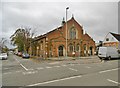
Gloucester, St. Stephen's
Former Anglican parish church on Bristol Road; closed in 2010: http://churchdb.gukutils.org.uk/GLS267.php https://www.gloucestershirelive.co.uk/whats-on/music-nightlife/could-become-gloucesters-next-new-1393965
Image: © Mike Faherty
Taken: 12 Oct 2018
0.10 miles
2
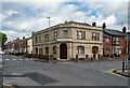
Former pub, Seymour Road, Gloucester
The Seymour, by J.F. Trew, 1895.
Now flats.
Image: © Stephen Richards
Taken: 18 May 2015
0.11 miles
3
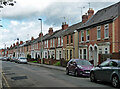
67-113 Seymour Road, Gloucester
Typical artisan housing of the last decades of the C19th.
Image: © Stephen Richards
Taken: 18 May 2015
0.12 miles
4
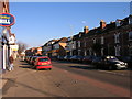
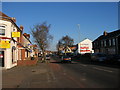
Gloucester: Bristol Road
Deserted Bristol Road ... it's still Christmas :).
Image: © Alby
Taken: 26 Dec 2008
0.13 miles
5
Gloucester: Bristol Road takeaways
Takeaways at Bristol Road in Gloucester.
Image: © Alby
Taken: 26 Dec 2008
0.14 miles
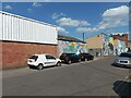
7

90 Price Street, Gloucester
The office block of the former timber works of Price, Walker & Co. Built in 1893-94 by the aptly-named W.B. Wood.
At the time occupied by a tile shop, Tileflair.
Image: © Stephen Richards
Taken: 18 May 2015
0.18 miles
8
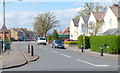
School safety zone speed limit, Linden Road, Gloucester
Viewed from near the mini-roundabout at the southern end of King Edward's Avenue.
A 20mph school safety speed limit applies ahead.
Image: © Jaggery
Taken: 13 Apr 2012
0.20 miles
9
Mitchell's Mural
A mural on the side of a building belonging to Mitchell's, an air conditioning company.
Image: © Pebble
Taken: 25 May 2023
0.21 miles
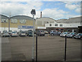
10
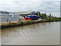
Timber yard alongside the Gloucester & Sharpness canal
Taken from the trip boat, Queen Boadicea II.
Image: © Christine Johnstone
Taken: 22 Jul 2011
0.22 miles