IMAGES TAKEN NEAR TO
The Greenway, GLOUCESTER, GL1 5NU
Introduction
This page details the photographs taken nearby to The Greenway, GL1 5NU by members of the Geograph project.
The Geograph project started in 2005 with the aim of publishing, organising and preserving representative images for every square kilometre of Great Britain, Ireland and the Isle of Man.

There are currently over 7.5m images from over14,400 individuals and you can help contribute to the project by visiting https://www.geograph.org.uk
Image Map
Images are licensed for reuse under creativecommons.org/licenses/by-sa/2.0
Notes
- Clicking on the map will re-center to the selected point.
- The higher the marker number, the further away the image location is from the centre of the postcode.
Image Listing (11 Images Found)
Images are licensed for reuse under creativecommons.org/licenses/by-sa/2.0
Image
Details
Distance
1
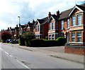
Podsmead Road houses in Gloucester
Viewed from near the Tuffley Avenue junction.
Image: © Jaggery
Taken: 13 Apr 2012
0.08 miles
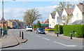
2
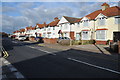
Podsmead Road
Podsmead Road in the southern suburbs of Gloucester.
Image: © Philip Halling
Taken: 26 Feb 2011
0.10 miles
3
Bowly Road Gloucester
Looking north from the corner of Tuffley Avenue in the Linden district of Gloucester.
A sign on the lamppost on the left shows that a 20mph speed limit is in force.
Image: © Jaggery
Taken: 13 Apr 2012
0.14 miles
4
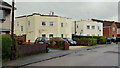
1930's deco housing, Gloucester
These two semi's stand out on this grey December afternoon in Tuffley Crescent.
Image: © Jonathan Billinger
Taken: 27 Dec 2012
0.14 miles
5
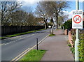
No cycling on the pavement in Tuffley Avenue Gloucester
The notice on a lamppost near the corner of The Oval states that it is an offence to cycle on the pavement. Maximum penalty £500.
Image: © Jaggery
Taken: 13 Apr 2012
0.16 miles
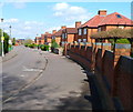
6

Houses on the NW side of The Oval, Gloucester
The Oval is an oval-shaped road enclosing The Oval Open Space in the Linden district of Gloucester.
Image: © Jaggery
Taken: 13 Apr 2012
0.21 miles
7
School safety zone speed limit, Linden Road, Gloucester
Viewed from near the mini-roundabout at the southern end of King Edward's Avenue.
A 20mph school safety speed limit applies ahead.
Image: © Jaggery
Taken: 13 Apr 2012
0.23 miles
8
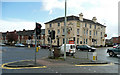
The Avenue Hotel
Situated on the busy intersection of Bristol Road and Tuffley Avenue, Gloucester.
Image: © Jonathan Billinger
Taken: 11 Apr 2008
0.23 miles
9

Tuffley Avenue Gloucester
Looking SE from the corner of The Oval. The long wall is part of the perimeter of a sports ground.
Image: © Jaggery
Taken: 13 Apr 2012
0.24 miles
10
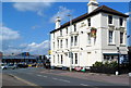
The Avenue, Gloucester
Pub on the corner of Tuffley Avenue and Bristol Road. Formerly named the Avenue Hotel.
A Lidl supermarket in Bristol Road is in the background.
Image: © Jaggery
Taken: 13 Apr 2012
0.24 miles