IMAGES TAKEN NEAR TO
Linden Road, GLOUCESTER, GL1 5HU
Introduction
This page details the photographs taken nearby to Linden Road, GL1 5HU by members of the Geograph project.
The Geograph project started in 2005 with the aim of publishing, organising and preserving representative images for every square kilometre of Great Britain, Ireland and the Isle of Man.

There are currently over 7.5m images from over14,400 individuals and you can help contribute to the project by visiting https://www.geograph.org.uk
Image Map
Images are licensed for reuse under creativecommons.org/licenses/by-sa/2.0
Notes
- Clicking on the map will re-center to the selected point.
- The higher the marker number, the further away the image location is from the centre of the postcode.
Image Listing (40 Images Found)
Images are licensed for reuse under creativecommons.org/licenses/by-sa/2.0
Image
Details
Distance
1
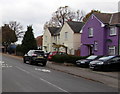
Purple house in a Gloucester suburb
Viewed across Linden Road.
Image: © Jaggery
Taken: 6 Nov 2016
0.04 miles
2
Linden Road towards Linden Primary School, Gloucester
Part of a School Safety Zone where the speed limit is 20mph.
Image: © Jaggery
Taken: 6 Nov 2016
0.05 miles
3
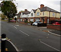
King Edward's Avenue houses, Gloucester
Viewed from the corner of Linden Road.
Image: © Jaggery
Taken: 6 Nov 2016
0.05 miles
4
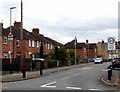
Linden Road School Safety Zone, Gloucester
A 20mph speed limit is in force on the approach to Linden Primary School.
Image: © Jaggery
Taken: 6 Nov 2016
0.05 miles
5
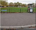
BT phonebox on a suburban corner of Gloucester
On the corner of King Edward's Avenue and Balfour Road.
Image: © Jaggery
Taken: 6 Nov 2016
0.06 miles
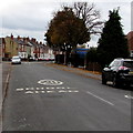
6
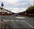
White painted roundabout at a suburban crossroads, Gloucester
At the crossroads of Linden Road (camera side and ahead),
The Oval on the right and King Edward's Avenue on the left.
Image: © Jaggery
Taken: 6 Nov 2016
0.07 miles
7
Warning sign - humps for 400 yards, The Oval, Gloucester
Facing the Linden Road junction, the sign is alongside the road named The Oval.
Image: © Jaggery
Taken: 6 Nov 2016
0.08 miles
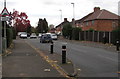
8
School safety zone speed limit, Linden Road, Gloucester
Viewed from near the mini-roundabout at the southern end of King Edward's Avenue.
A 20mph school safety speed limit applies ahead.
Image: © Jaggery
Taken: 13 Apr 2012
0.10 miles
9
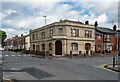
Former pub, Seymour Road, Gloucester
The Seymour, by J.F. Trew, 1895.
Now flats.
Image: © Stephen Richards
Taken: 18 May 2015
0.11 miles
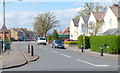
10
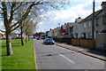
Lannett Road, Gloucester
The shape of Lannett Road is three sides of a rectangle, along the southern, eastern and northern edges of The Lannett Recreation Ground. http://www.geograph.org.uk/photo/2906294 This view of Lannett Road is along the southern side.
Image: © Jaggery
Taken: 13 Apr 2012
0.12 miles