IMAGES TAKEN NEAR TO
Sydenham Terrace, GLOUCESTER, GL1 5EA
Introduction
This page details the photographs taken nearby to Sydenham Terrace, GL1 5EA by members of the Geograph project.
The Geograph project started in 2005 with the aim of publishing, organising and preserving representative images for every square kilometre of Great Britain, Ireland and the Isle of Man.

There are currently over 7.5m images from over14,400 individuals and you can help contribute to the project by visiting https://www.geograph.org.uk
Image Map
Images are licensed for reuse under creativecommons.org/licenses/by-sa/2.0
Notes
- Clicking on the map will re-center to the selected point.
- The higher the marker number, the further away the image location is from the centre of the postcode.
Image Listing (84 Images Found)
Images are licensed for reuse under creativecommons.org/licenses/by-sa/2.0
Image
Details
Distance
1
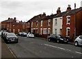
Sydenham Terrace, Gloucester
From Stanley Terrace along Sydenham Terrace towards Calton Road.
Image: © Jaggery
Taken: 6 Nov 2016
0.02 miles
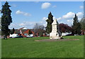
2

Detail of the Thomas Nelson Foster Memorial
Image: © Philip Halling
Taken: 26 Feb 2011
0.02 miles
3
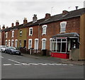
Dyke's Fish & Chips Shop, Gloucester
At 23 Sydenham Terrace, on the corner of Stanley Road.
Image: © Jaggery
Taken: 6 Nov 2016
0.02 miles
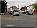
4
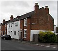
Corner of Stanley Road and Churchill Road, Gloucester
The car is parked in Stanley Road.
Image: © Jaggery
Taken: 6 Nov 2016
0.03 miles
5
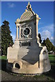
Thomas Nelson Foster Memorial
This memorial was erected by public subscription at a cost of £250. The inscription reads:
'In memory of Thomas Nelson Foster, J.P., Christian, Citizen and Merchant, who died at sea 2nd October 1901'.
When it was unveiled in 1902 it also included a drinking fountain and had electric lights on the corners. Thomas Nelson Foster was the owner of Foster Brothers, an oil mill at Baker's Quay in the Docks. Originally the company was based in Evesham but relocated in 1863. Among the goods handled were linseed which was imported from Russia, Argentina and India, and cotton seed from Egypt.
Foster Brothers employed 129 workers in 1897, and amalgamated with other firms in 1899 to form British Oil and Cake Mills Limited. Information sourced from: http://www.geograph.org.uk/submit2.php#gridref=SO8317
Image: © Philip Halling
Taken: 26 Feb 2011
0.03 miles
6
Thomas Nelson Foster Memorial, Gloucester
Located in Sydenham Garden, a roughly triangular area of grass and trees between Sydenham Terrace, Stanley Terrace and Stroud Road. http://www.geograph.org.uk/photo/2295426 for details.
Image: © Jaggery
Taken: 13 Apr 2012
0.05 miles
7
Northern end of Stanley Terrace, Gloucester
The 30mph speed limit on Stroud Road drops to 20mph on Stanley Terrace.
Image: © Jaggery
Taken: 6 Nov 2016
0.05 miles
8
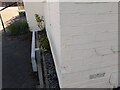
Ordnance Survey Cut Mark
This OS cut mark can be found on No8 Goodwin Court. It marks a point 19.030m above mean sea level.
Image: © Adrian Dust
Taken: 9 Jul 2022
0.05 miles
9
Corner of Stanley Terrace and Robinson Road, Gloucester
Stanley Terrace is on the left.
Image: © Jaggery
Taken: 6 Nov 2016
0.07 miles
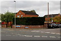
10
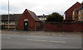
Stroud Road electricity substation, Gloucester
The Western Power Distribution electricity substation identifier is STROUD RD S/S 4550.
A warning on the substation shows the presence of SF6 (sulphur hexafluoride, an insulating gas used in high voltage systems).
Image: © Jaggery
Taken: 6 Nov 2016
0.07 miles