IMAGES TAKEN NEAR TO
Stanley Road, GLOUCESTER, GL1 5DQ
Introduction
This page details the photographs taken nearby to Stanley Road, GL1 5DQ by members of the Geograph project.
The Geograph project started in 2005 with the aim of publishing, organising and preserving representative images for every square kilometre of Great Britain, Ireland and the Isle of Man.

There are currently over 7.5m images from over14,400 individuals and you can help contribute to the project by visiting https://www.geograph.org.uk
Image Map
Images are licensed for reuse under creativecommons.org/licenses/by-sa/2.0
Notes
- Clicking on the map will re-center to the selected point.
- The higher the marker number, the further away the image location is from the centre of the postcode.
Image Listing (72 Images Found)
Images are licensed for reuse under creativecommons.org/licenses/by-sa/2.0
Image
Details
Distance
1
NE end of Calton Road, Gloucester
Houses on the west side of Calton Road, viewed from the Sydenham Terrace end.
Image: © Jaggery
Taken: 13 Apr 2012
0.01 miles
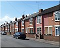
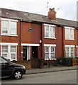
2
Cars and houses, Stanley Road, Gloucester
Viewed on a Sunday afternoon. No doubt fewer cars would be here at this time on Monday-Friday.
Image: © Jaggery
Taken: 6 Nov 2016
0.02 miles
3
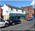
Gloucester Florists, Calton Road, Gloucester
Located at 2b Calton Road. Its neighbour on the right is the Michael Tuck estate agency http://www.geograph.org.uk/photo/2905454 on the corner of Sydenham Terrace.
Image: © Jaggery
Taken: 13 Apr 2012
0.06 miles
4
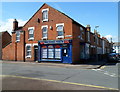
Michael Tuck estate agents office, Linden, Gloucester
Located on the corner of Calton Road and Sydenham Terrace.
Established in 1983, the firm has 7 offices, in the Gloucester, Worcester and Swindon areas.
Image: © Jaggery
Taken: 13 Apr 2012
0.06 miles
5
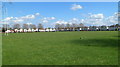
The Lannett Recreation Ground
Viewed from the corner of King Edward's Avenue and Lannett Road.
Image: © Jaggery
Taken: 13 Apr 2012
0.06 miles
6
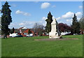
Thomas Nelson Foster Memorial, Gloucester
Located in Sydenham Garden, a roughly triangular area of grass and trees between Sydenham Terrace, Stanley Terrace and Stroud Road. http://www.geograph.org.uk/photo/2295426 for details.
Image: © Jaggery
Taken: 13 Apr 2012
0.07 miles
7
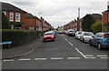
Stanley Road, Gloucester
Viewed across Linden Road. An Asda home delivery van is in the middle of the road.
Image: © Jaggery
Taken: 6 Nov 2016
0.07 miles
8
Lannett Road, Gloucester
Examples of the city's early council housing, built from 1920. "The only distinguishing feature [is] the exceptionally generous allowance of open space."
Image: © Stephen Richards
Taken: 18 May 2015
0.08 miles
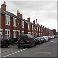
9
Banwell Terrace name, Stanley Road, Gloucester
This is one of several separately named rows of houses in Stanley Road.
Image: © Jaggery
Taken: 6 Nov 2016
0.08 miles
10
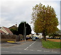
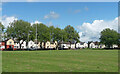
North side of Lannett Road, Gloucester
Lannett Road is on three sides (north, east and south) of The Lannett,
a roughly rectangular recreation area. King Edward's Avenue is on the west side.
Image: © Jaggery
Taken: 6 Nov 2016
0.09 miles