1
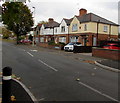
King Edward's Avenue houses, Gloucester
Viewed from the corner of Linden Road.
Image: © Jaggery
Taken: 6 Nov 2016
0.03 miles
2
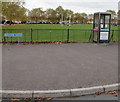
BT phonebox on a suburban corner of Gloucester
On the corner of King Edward's Avenue and Balfour Road.
Image: © Jaggery
Taken: 6 Nov 2016
0.03 miles
3
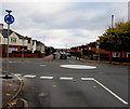
White painted roundabout at a suburban crossroads, Gloucester
At the crossroads of Linden Road (camera side and ahead),
The Oval on the right and King Edward's Avenue on the left.
Image: © Jaggery
Taken: 6 Nov 2016
0.04 miles
4
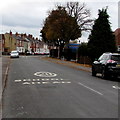
Lannett Road, Gloucester
The shape of Lannett Road is three sides of a rectangle, along the southern, eastern and northern edges of The Lannett Recreation Ground. http://www.geograph.org.uk/photo/2906294 This view of Lannett Road is along the southern side.
Image: © Jaggery
Taken: 13 Apr 2012
0.05 miles
5
Warning sign - humps for 400 yards, The Oval, Gloucester
Facing the Linden Road junction, the sign is alongside the road named The Oval.
Image: © Jaggery
Taken: 6 Nov 2016
0.05 miles
6
Linden Road School Safety Zone, Gloucester
A 20mph speed limit is in force on the approach to Linden Primary School.
Image: © Jaggery
Taken: 6 Nov 2016
0.05 miles
7
Purple house in a Gloucester suburb
Viewed across Linden Road.
Image: © Jaggery
Taken: 6 Nov 2016
0.05 miles
8
Linden Road towards Linden Primary School, Gloucester
Part of a School Safety Zone where the speed limit is 20mph.
Image: © Jaggery
Taken: 6 Nov 2016
0.05 miles
9
Fallen leaves, Lannett Road, Gloucester
Hundreds of fallen leaves lie on and near Lannett Road on November 6th 2016.
Image: © Jaggery
Taken: 6 Nov 2016
0.07 miles
10
King George VI pillarbox on a Gloucester corner
On the corner of Rosebery Avenue and Linden Road.
Image: © Jaggery
Taken: 6 Nov 2016
0.10 miles


