IMAGES TAKEN NEAR TO
Bloomfield Road, GLOUCESTER, GL1 5BL
Introduction
This page details the photographs taken nearby to Bloomfield Road, GL1 5BL by members of the Geograph project.
The Geograph project started in 2005 with the aim of publishing, organising and preserving representative images for every square kilometre of Great Britain, Ireland and the Isle of Man.

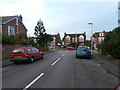
There are currently over 7.5m images from over14,400 individuals and you can help contribute to the project by visiting https://www.geograph.org.uk
Image Map
Images are licensed for reuse under creativecommons.org/licenses/by-sa/2.0
Notes
- Clicking on the map will re-center to the selected point.
- The higher the marker number, the further away the image location is from the centre of the postcode.
Image Listing (89 Images Found)
Images are licensed for reuse under creativecommons.org/licenses/by-sa/2.0
Image
Details
Distance
1
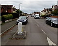
Central Road
Not sure why it merits this name.
Image: © HelenK
Taken: 12 Sep 2016
0.06 miles
2
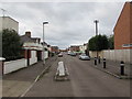
West along Robinson Road, Gloucester
From King Edward's Avenue along Robinson Road towards Central Road.
Image: © Jaggery
Taken: 6 Nov 2016
0.06 miles
3
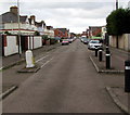
West along Robinson Road, Gloucester
Robinson Road between King Edward's Avenue and Central Road.
This is a one-way road - all the cars are facing the camera.
Image: © Jaggery
Taken: 6 Nov 2016
0.06 miles
4
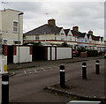
Robinson Road houses, Gloucester
Viewed from the corner of King Edward's Avenue.
Image: © Jaggery
Taken: 6 Nov 2016
0.09 miles
5
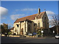
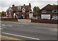
St Paul's, Stroud Road
This church is situated at the junction of Park End Road and Stroud Road.
Image: © David Stowell
Taken: 13 Nov 2005
0.11 miles
6
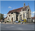
The Church of St Paul and St Stephen, Gloucester
Anglican church located at the crossroads of Park End Road, King Edward's Avenue and Stroud Road.
Image: © Jaggery
Taken: 13 Apr 2012
0.11 miles
7
Ordnance Survey Cut Mark
This OS cut mark can be found on the brick post of No31 Robinson Road. It marks a point 16.639m above mean sea level.
Image: © Adrian Dust
Taken: 9 Jul 2022
0.11 miles
8
West along Churchill Road, Gloucester
From the corner of King Edward's Avenue.
Image: © Jaggery
Taken: 6 Nov 2016
0.11 miles
9
Bramble House, Gloucester
Residential care home at 98 Stroud Road.
Image: © Jaggery
Taken: 6 Nov 2016
0.12 miles
10
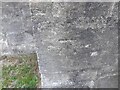
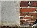
Ordnance Survey Cut Mark
This OS cut mark can be found on the SW face of St Pauls Church. It marks a point 16.930m above mean sea level.
Image: © Adrian Dust
Taken: 9 Jul 2022
0.12 miles