IMAGES TAKEN NEAR TO
New Street, GLOUCESTER, GL1 5AZ
Introduction
This page details the photographs taken nearby to New Street, GL1 5AZ by members of the Geograph project.
The Geograph project started in 2005 with the aim of publishing, organising and preserving representative images for every square kilometre of Great Britain, Ireland and the Isle of Man.

There are currently over 7.5m images from over14,400 individuals and you can help contribute to the project by visiting https://www.geograph.org.uk
Image Map
Images are licensed for reuse under creativecommons.org/licenses/by-sa/2.0
Notes
- Clicking on the map will re-center to the selected point.
- The higher the marker number, the further away the image location is from the centre of the postcode.
Image Listing (113 Images Found)
Images are licensed for reuse under creativecommons.org/licenses/by-sa/2.0
Image
Details
Distance
1
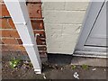
Ordnance Survey Cut Mark
This OS cut mark can be found on No17 New Street. It marks a point 13.609m above mean sea level.
Image: © Adrian Dust
Taken: 9 Jul 2022
0.05 miles
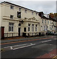
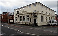
2
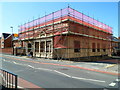
Former Park End pub, Gloucester
The location is the corner of New Street and Park End Road.
A Gloucester City Council planning application granted in 2010 is for the demolition of the Park End public house and the erection of 14 residential units: 6 2-bedroom apartments and 8 3-bedroom houses.
Image: © Jaggery
Taken: 13 Apr 2012
0.05 miles
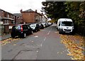
3
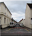
West along New Street, Gloucester
From the B4072 Park End Road.
Image: © Jaggery
Taken: 6 Nov 2016
0.05 miles
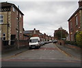
4
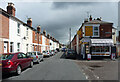
New Street, Gloucester
Terraced housing of c1870.
There is a corner shop at the junction with St Paul's Road.
Image: © Stephen Richards
Taken: 18 May 2015
0.06 miles
5
Weston Road, Gloucester
From the corner of Park End Road. The railings and trees are alongside Sud Brook.
Image: © Jaggery
Taken: 6 Nov 2016
0.07 miles
6
St Paul's Road, Gloucester
From Park End Road along St Paul's Road towards New Street.
Image: © Jaggery
Taken: 6 Nov 2016
0.09 miles
7
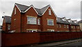
Recently-built flats, Park End Road, Gloucester
On the site of the former Park End pub.
Image: © Jaggery
Taken: 6 Nov 2016
0.09 miles
8
Crown Green Court, Gloucester
Park End Road side of flats on the corner of New Street, on the site formerly occupied by the Park End pub.
http://www.geograph.org.uk/photo/5184474 to the pub-style name sign.
Image: © Jaggery
Taken: 6 Nov 2016
0.09 miles
9
Crown Green Court, Gloucester
Flats on the corner of New Street and Park End Road, on the site formerly occupied by the Park End pub.
Image: © Jaggery
Taken: 6 Nov 2016
0.10 miles
10
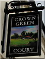
Crown Green Court name sign, Park End Road, Gloucester
Located here. http://www.geograph.org.uk/photo/5184465 The pub-style name sign is on flats on the site of the former Park End pub.
Image: © Jaggery
Taken: 6 Nov 2016
0.10 miles