IMAGES TAKEN NEAR TO
Park End Road, GLOUCESTER, GL1 5AT
Introduction
This page details the photographs taken nearby to Park End Road, GL1 5AT by members of the Geograph project.
The Geograph project started in 2005 with the aim of publishing, organising and preserving representative images for every square kilometre of Great Britain, Ireland and the Isle of Man.

There are currently over 7.5m images from over14,400 individuals and you can help contribute to the project by visiting https://www.geograph.org.uk
Image Map
Images are licensed for reuse under creativecommons.org/licenses/by-sa/2.0
Notes
- Clicking on the map will re-center to the selected point.
- The higher the marker number, the further away the image location is from the centre of the postcode.
Image Listing (144 Images Found)
Images are licensed for reuse under creativecommons.org/licenses/by-sa/2.0
Image
Details
Distance
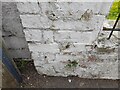
1
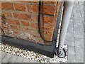
Ordnance Survey Cut Mark
This OS cut mark can be found on No11 Parkend Road. It marks a point 14.505m above mean sea level.
Image: © Adrian Dust
Taken: 9 Jul 2022
0.00 miles
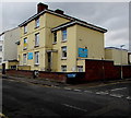
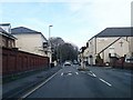
2
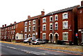
Three-storey houses, Park End Road, Gloucester
Ebley House and Aston House are on the right.
Image: © Jaggery
Taken: 6 Nov 2016
0.02 miles
3
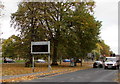
Traffic information board, Park End Road, Gloucester
On a Sunday afternoon, the board displays the number of free spaces in four city centre car parks.
Image: © Jaggery
Taken: 6 Nov 2016
0.02 miles
4
East side of Midland Road, Gloucester
Midland Road houses between Regent Street and Brook Street.
Image: © Jaggery
Taken: 6 Nov 2016
0.03 miles
5
Ukrainian Social Club, Gloucester
The yellow and blue national flag of Ukraine is on a small flagpole of the wall
of the Ukrainian Social Club at 37 Midland Road, on the corner of Brook Street.
Image: © Jaggery
Taken: 6 Nov 2016
0.03 miles
6
Ordnance Survey Cut Mark
This OS cut mark can be found on the wall of No30 Midland Road. It marks a point 15.136m above mean sea level.
Image: © Adrian Dust
Taken: 9 Jul 2022
0.04 miles
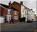
7
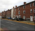
Three-storey houses, Park End Road, Gloucester
Viewed from the corner of Weston Road.
Image: © Jaggery
Taken: 6 Nov 2016
0.04 miles
8
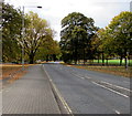
Trier Way, Gloucester
The A430 Trier Way southwest of the Park End Road junction. Gloucester Park is on the right.
Image: © Jaggery
Taken: 6 Nov 2016
0.05 miles
10
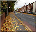
Autumn leaves, Park End Road, Gloucester
Viewed on November 6th 2016.
Image: © Jaggery
Taken: 6 Nov 2016
0.06 miles