IMAGES TAKEN NEAR TO
Park End Road, GLOUCESTER, GL1 5AL
Introduction
This page details the photographs taken nearby to Park End Road, GL1 5AL by members of the Geograph project.
The Geograph project started in 2005 with the aim of publishing, organising and preserving representative images for every square kilometre of Great Britain, Ireland and the Isle of Man.

There are currently over 7.5m images from over14,400 individuals and you can help contribute to the project by visiting https://www.geograph.org.uk
Image Map
Images are licensed for reuse under creativecommons.org/licenses/by-sa/2.0
Notes
- Clicking on the map will re-center to the selected point.
- The higher the marker number, the further away the image location is from the centre of the postcode.
Image Listing (108 Images Found)
Images are licensed for reuse under creativecommons.org/licenses/by-sa/2.0
Image
Details
Distance
1
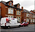
FK Meble van in Park End Road Gloucester, a long way from home
The letters WRA on the van's registration plate indicate the Radom district of Poland.
Text on the white van is in Polish.
Image: © Jaggery
Taken: 6 Nov 2016
0.01 miles
2
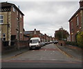
St Paul's Road, Gloucester
From Park End Road along St Paul's Road towards New Street.
Image: © Jaggery
Taken: 6 Nov 2016
0.02 miles
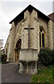
3
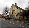
East side of the Church of St Paul and St Stephen, Gloucester
Viewed across Park End Road. The church is part of the Church of England Diocese of Gloucester.
Image: © Jaggery
Taken: 6 Nov 2016
0.04 miles
5
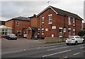
St Paul's Residential Home, Gloucester
The Park End Road side of the residential home on the corner of Stroud Road.
Image: © Jaggery
Taken: 6 Nov 2016
0.04 miles
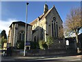
6
War Memorial at a Gloucester church entrance
Located here http://www.geograph.org.uk/photo/2905496 at the entrance to the Church of St Paul and St Stephen.
Image: © Jaggery
Taken: 6 Nov 2016
0.04 miles
7
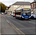
Tuffley Court bus in Park End Road, Gloucester
Stagecoach bus, fleet number 37325, is on route 9 to Tuffley Court via Stroud Road.
Image: © Jaggery
Taken: 6 Nov 2016
0.04 miles
8
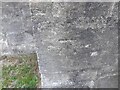
Ordnance Survey Cut Mark
This OS cut mark can be found on the SW face of St Pauls Church. It marks a point 16.930m above mean sea level.
Image: © Adrian Dust
Taken: 9 Jul 2022
0.04 miles
9
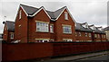
Recently-built flats, Park End Road, Gloucester
On the site of the former Park End pub.
Image: © Jaggery
Taken: 6 Nov 2016
0.05 miles
10
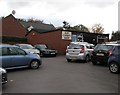
Elim Charity Shop, Gloucester
Set back from Park End Road, on the south side of Gloucester Elim Church. http://www.geograph.org.uk/photo/5184424
Image: © Jaggery
Taken: 6 Nov 2016
0.05 miles