IMAGES TAKEN NEAR TO
Hewelsfield, LYDNEY, GL15 6UZ
Introduction
This page details the photographs taken nearby to GL15 6UZ by members of the Geograph project.
The Geograph project started in 2005 with the aim of publishing, organising and preserving representative images for every square kilometre of Great Britain, Ireland and the Isle of Man.

There are currently over 7.5m images from over14,400 individuals and you can help contribute to the project by visiting https://www.geograph.org.uk
Image Map
Images are licensed for reuse under creativecommons.org/licenses/by-sa/2.0
Notes
- Clicking on the map will re-center to the selected point.
- The higher the marker number, the further away the image location is from the centre of the postcode.
Image Listing (7 Images Found)
Images are licensed for reuse under creativecommons.org/licenses/by-sa/2.0
Image
Details
Distance
2
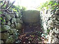
Stone Stile, Hewelsfield Common
On Gloucestershire footpath FHE17 looking NW. The view looking in is Image
Image: © Mr Red
Taken: 26 Aug 2024
0.15 miles
3
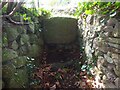
Stone Stile, Hewelsfield Common
On Gloucestershire footpath FHE17 looking se. The view looking out is Image
Image: © Mr Red
Taken: 26 Aug 2024
0.15 miles
4
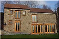
West facing cottage
Glowing in the winter afternoon sunshine.
Image: © Jonathan Billinger
Taken: 28 Dec 2006
0.16 miles
5
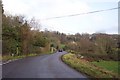
Lane near Grove Farm
Looking west towards Hewelsfield Common.
Image: © Jonathan Billinger
Taken: 28 Dec 2006
0.18 miles
6
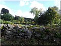
Dry stone wall and garden beyond, Mill Hill, Gloucestershire
Image: © nick macneill
Taken: 13 Oct 2012
0.19 miles
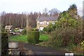
7
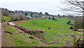
Hewelsfield Common
A scattered rural community on the slopes to the east of the Wye Gorge at Brockweir.
Image: © Jonathan Billinger
Taken: 8 Feb 2012
0.25 miles