IMAGES TAKEN NEAR TO
Pettymarsh Lane, LYDNEY, GL15 6UG
Introduction
This page details the photographs taken nearby to Pettymarsh Lane, GL15 6UG by members of the Geograph project.
The Geograph project started in 2005 with the aim of publishing, organising and preserving representative images for every square kilometre of Great Britain, Ireland and the Isle of Man.

There are currently over 7.5m images from over14,400 individuals and you can help contribute to the project by visiting https://www.geograph.org.uk
Image Map
Images are licensed for reuse under creativecommons.org/licenses/by-sa/2.0
Notes
- Clicking on the map will re-center to the selected point.
- The higher the marker number, the further away the image location is from the centre of the postcode.
Image Listing (17 Images Found)
Images are licensed for reuse under creativecommons.org/licenses/by-sa/2.0
Image
Details
Distance
1
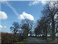
Harpfield near St Briavels
Harpfield to the south of the village of St Briavels.
Image: © Philip Halling
Taken: 10 Aug 2017
0.05 miles
2
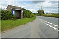
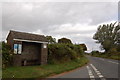
Bus shelter near St Briavels
Bus shelter on the B4228 just south of St Briavels.
Image: © Philip Halling
Taken: 10 Aug 2017
0.08 miles
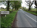
3
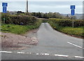
Petty Marsh near St Briavels
The lane named Petty Marsh heads west away from the B4228 Coleford Road towards Coldharbour and St Briavels Common. Signs show that the lane is a single-track road with passing places, unsuitable for heavy goods vehicles.
Image: © Jaggery
Taken: 12 May 2013
0.08 miles
4
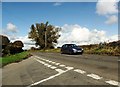
Horsepool Lane near St Briavels
Horsepool Lane heads west away from the B4228 Coleford Road towards Coldharbour and St Briavels Common. Signs show that the lane is a single-track road with passing places, unsuitable for heavy goods vehicles.
Image: © Jaggery
Taken: 12 May 2013
0.09 miles
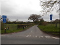
8
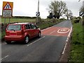
End of the 30mph zone in St Briavels
Viewed along the B4228 heading south away from St Briavels. The 30mph speed limit in St Briavels increases to the National Speed Limit, so oncoming cars in the middle of the road could now legally approach you at up to 60mph...
Image: © Jaggery
Taken: 12 May 2013
0.13 miles
9
Old-style boundary sign, St Briavels
Located alongside the B4228 Coleford Road at the southern approach to St Briavels. This sign is about 700 metres south of newer signs showing the village boundary, so it is unclear where the actual boundary is.
Image: © Jaggery
Taken: 12 May 2013
0.14 miles