IMAGES TAKEN NEAR TO
Castle Crescent, LYDNEY, GL15 6UA
Introduction
This page details the photographs taken nearby to Castle Crescent, GL15 6UA by members of the Geograph project.
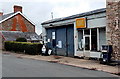
The Geograph project started in 2005 with the aim of publishing, organising and preserving representative images for every square kilometre of Great Britain, Ireland and the Isle of Man.

There are currently over 7.5m images from over14,400 individuals and you can help contribute to the project by visiting https://www.geograph.org.uk
Image Map
Images are licensed for reuse under creativecommons.org/licenses/by-sa/2.0
Notes
- Clicking on the map will re-center to the selected point.
- The higher the marker number, the further away the image location is from the centre of the postcode.
Image Listing (151 Images Found)
Images are licensed for reuse under creativecommons.org/licenses/by-sa/2.0
Image
Details
Distance
1
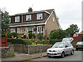
St Briavels - St Bruel's Close
A well-kept garden.
Image: © Roy Parkhouse
Taken: 12 Jul 2006
0.02 miles
2
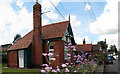
St Briavels - Almshouses
According to a plaque in the visible gable end : "These almshouses were erected in 1895 in accordance with the will of the late C. Lord Denton Esqre by his nephew O.W. Andrews surgeon R.N."
Image: © Roy Parkhouse
Taken: 9 Aug 2007
0.02 miles
3
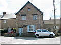
St Briavels - St Marys Chantry 700-1536
The plaque bearing this information is above, and to the right of, the door.
Image: © Roy Parkhouse
Taken: 9 Aug 2007
0.02 miles
4
Derelict fuel pump, St Briavels
Located in front of this http://www.geograph.org.uk/photo/3458175 derelict garage.
Image: © Jaggery
Taken: 12 May 2013
0.04 miles
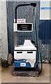
5
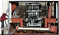
Innards of an old petrol pump, St Briavels
Image: © Ruth Sharville
Taken: 11 Feb 2022
0.04 miles
6
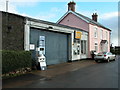
Traditional village garage, St Briavels
Once found in many villages most of these small village garages have now gone and the land redeveloped.
In October 2014 I viewed this picture and was reflecting as to whether business was still trading, a quick browse on Geograph reveals in 2013 it was photographed again and has closed. Image]
Image: © Philip Halling
Taken: 26 Nov 2006
0.04 miles
7
Old Boot Shop, St Briavels
The names of several houses in St Briavels refer to a previous usage of the building.
This one is Old Boot Shop in East Street.
Image: © Jaggery
Taken: 12 May 2013
0.04 miles
8
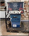
Derelict DERV pump, St Briavels
Located in front of this http://www.geograph.org.uk/photo/3458175 derelict garage.
Image: © Jaggery
Taken: 12 May 2013
0.04 miles
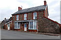
9
Derelict former garage, East Street, St Briavels
Now (May 2013) an eyesore in a pretty village, this http://www.geograph.org.uk/photo/285938 was how the garage looked in 2006.
Image: © Jaggery
Taken: 12 May 2013
0.05 miles
10
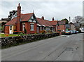
Late Victorian almshouses, St Briavels
An inscription in stone on the left side of the almshouses shows that they were erected in 1895
in accordance with the will of the late C. Lord Denton Esq.
Image: © Jaggery
Taken: 12 May 2013
0.05 miles