IMAGES TAKEN NEAR TO
Smithville Close, LYDNEY, GL15 6TN
Introduction
This page details the photographs taken nearby to Smithville Close, GL15 6TN by members of the Geograph project.
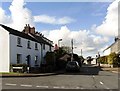
The Geograph project started in 2005 with the aim of publishing, organising and preserving representative images for every square kilometre of Great Britain, Ireland and the Isle of Man.

There are currently over 7.5m images from over14,400 individuals and you can help contribute to the project by visiting https://www.geograph.org.uk
Image Map
Images are licensed for reuse under creativecommons.org/licenses/by-sa/2.0
Notes
- Clicking on the map will re-center to the selected point.
- The higher the marker number, the further away the image location is from the centre of the postcode.
Image Listing (49 Images Found)
Images are licensed for reuse under creativecommons.org/licenses/by-sa/2.0
Image
Details
Distance
1
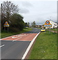
NE approach to St Briavels
The B4228 from Coleford passes a combined St Briavels boundary sign and 30mph speed limit sign. Briavels is pronounced Brevels.
Image: © Jaggery
Taken: 12 May 2013
0.05 miles
2
St Briavels telephone exchange
Set back from the B4228 at the NE edge of the village.
Image: © Jaggery
Taken: 12 May 2013
0.07 miles
3
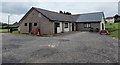
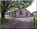
Sports pavilion, St Briavels
Located in the SE corner of playing fields and a recreation area north of East Street and west of the B4228 Coleford Road.
Image: © Jaggery
Taken: 12 May 2013
0.08 miles
4
Road junction in St Briavels
The junction of Bream Road with Barrowell Lane in St Briavels.
Image: © Philip Halling
Taken: 10 Aug 2017
0.08 miles
5
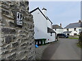
Approaching the junction with Bream Road, St Briavels
Note the old road sign for "children playing" affixed to the wall to the left of the image. See Image
Image: © Ruth Sharville
Taken: 11 Feb 2022
0.09 miles
6
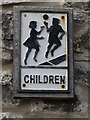
Close look at old road sign for "children playing" - on a wall at St Briavels
See Image for context.
Image: © Ruth Sharville
Taken: 11 Feb 2022
0.09 miles
8
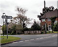
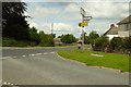
Distances from St Briavels
The location is the crossroads of the B4228, East Street and Cross Keys.
The signpost arm pointing left along the B4228 shows 5 miles to Coleford and 6 to Berry Hill.
The arm pointing right shows 2 miles to Hewelsfield and 7 to Chepstow.
The arm pointing away from the camera along Cross Keys shows 3 miles to Bream.
Image: © Jaggery
Taken: 12 May 2013
0.10 miles
10
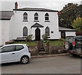
The Steps, East Street, St Briavels
The Steps is a distinctively-windowed detached house at the SE end of East Street.
Image: © Jaggery
Taken: 12 May 2013
0.11 miles