IMAGES TAKEN NEAR TO
Rookery Lane, LYDNEY, GL15 6RZ
Introduction
This page details the photographs taken nearby to Rookery Lane, GL15 6RZ by members of the Geograph project.
The Geograph project started in 2005 with the aim of publishing, organising and preserving representative images for every square kilometre of Great Britain, Ireland and the Isle of Man.

There are currently over 7.5m images from over14,400 individuals and you can help contribute to the project by visiting https://www.geograph.org.uk
Image Map
Images are licensed for reuse under creativecommons.org/licenses/by-sa/2.0
Notes
- Clicking on the map will re-center to the selected point.
- The higher the marker number, the further away the image location is from the centre of the postcode.
Image Listing (5 Images Found)
Images are licensed for reuse under creativecommons.org/licenses/by-sa/2.0
Image
Details
Distance
1
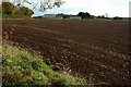
Inwood Farm
Inwood Farm between Clearwell and Newland.
Image: © Philip Halling
Taken: 30 Oct 2010
0.01 miles
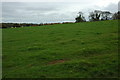
2
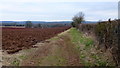
Footpath to Valley House
A nice wide grassy headland to walk on.
Image: © Jonathan Billinger
Taken: 22 Feb 2013
0.09 miles
3
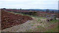
Arable land near Newland
Looking south-west.
Image: © Jonathan Billinger
Taken: 22 Feb 2013
0.12 miles
4
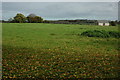
Farmland near Clearwell
Farmland and a converted barn to the west of Clearwell.
Image: © Philip Halling
Taken: 30 Oct 2010
0.15 miles
5
Farmland near Clearwell
Farmland to the west of the village and castle of Clearwell.
Image: © Philip Halling
Taken: 30 Oct 2010
0.23 miles