IMAGES TAKEN NEAR TO
St. Briavels, LYDNEY, GL15 6RA
Introduction
This page details the photographs taken nearby to GL15 6RA by members of the Geograph project.
The Geograph project started in 2005 with the aim of publishing, organising and preserving representative images for every square kilometre of Great Britain, Ireland and the Isle of Man.

There are currently over 7.5m images from over14,400 individuals and you can help contribute to the project by visiting https://www.geograph.org.uk
Image Map
Images are licensed for reuse under creativecommons.org/licenses/by-sa/2.0
Notes
- Clicking on the map will re-center to the selected point.
- The higher the marker number, the further away the image location is from the centre of the postcode.
Image Listing (7 Images Found)
Images are licensed for reuse under creativecommons.org/licenses/by-sa/2.0
Image
Details
Distance
1
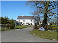
Close Turf House
Between St. Briavels and Bream.
Image: © Jonathan Billinger
Taken: 8 Mar 2010
0.05 miles
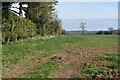
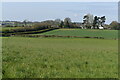
3
Track and field boundary, near Close Turf Farm
Image: © Ruth Sharville
Taken: 6 Jul 2013
0.18 miles
4
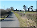
Lane to St. Briavels
Looking west past Close Turf Farm.
Image: © Jonathan Billinger
Taken: 8 Mar 2010
0.18 miles
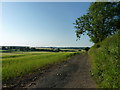
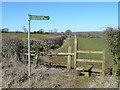
6

Field edge from stile beside Bream Road
Image: © David Martin
Taken: 3 Apr 2022
0.20 miles
7
The Gloucestershire Way between St. Briavels and Bream
A stile giving way to a young arable crop.
Image: © Jonathan Billinger
Taken: 8 Mar 2010
0.24 miles