IMAGES TAKEN NEAR TO
Coxbury Lane, LYDNEY, GL15 6QJ
Introduction
This page details the photographs taken nearby to Coxbury Lane, GL15 6QJ by members of the Geograph project.
The Geograph project started in 2005 with the aim of publishing, organising and preserving representative images for every square kilometre of Great Britain, Ireland and the Isle of Man.

There are currently over 7.5m images from over14,400 individuals and you can help contribute to the project by visiting https://www.geograph.org.uk
Image Map
Images are licensed for reuse under creativecommons.org/licenses/by-sa/2.0
Notes
- Clicking on the map will re-center to the selected point.
- The higher the marker number, the further away the image location is from the centre of the postcode.
Image Listing (5 Images Found)
Images are licensed for reuse under creativecommons.org/licenses/by-sa/2.0
Image
Details
Distance
1
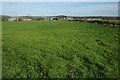
Lodges Barn Farm
Lodges Barn Farm viewed from the footpath to the south-west.
Image: © Philip Halling
Taken: 30 Oct 2010
0.03 miles
2
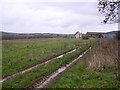
Farmland above the Wye Valley
The fields of this farm slope down gently to the edge of the steep sided Wye Valley. The photograph illustrates a traditional farmhouse with barn conversion indicating diversification.
Image: © Gill Stott
Taken: 1 Jan 2007
0.04 miles
3
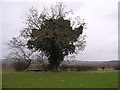
Pastureland and distinctive tree above the Wye Valley
Ash tree clad in ivy as part of a degrading hedgerow bordering pastureland.
Image: © Gill Stott
Taken: 1 Jan 2007
0.04 miles
4
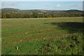
View to Newland
View across farmland near Lodges Barn Farm to Newland.
Image: © Philip Halling
Taken: 30 Oct 2010
0.08 miles
5
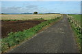
Driveway to Lodges Barn Farm
Drive to Lodges Barn Farm high above the Wye valley.
Image: © Philip Halling
Taken: 30 Oct 2010
0.19 miles