IMAGES TAKEN NEAR TO
Parkhill, LYDNEY, GL15 6PU
Introduction
This page details the photographs taken nearby to Parkhill, GL15 6PU by members of the Geograph project.
The Geograph project started in 2005 with the aim of publishing, organising and preserving representative images for every square kilometre of Great Britain, Ireland and the Isle of Man.

There are currently over 7.5m images from over14,400 individuals and you can help contribute to the project by visiting https://www.geograph.org.uk
Image Map
Images are licensed for reuse under creativecommons.org/licenses/by-sa/2.0
Notes
- Clicking on the map will re-center to the selected point.
- The higher the marker number, the further away the image location is from the centre of the postcode.
Image Listing (4 Images Found)
Images are licensed for reuse under creativecommons.org/licenses/by-sa/2.0
Image
Details
Distance
1
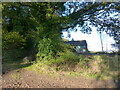
Overgrown track and derelict hut, High Woolaston, Gloucestershire
Image: © Ruth Sharville
Taken: 13 Nov 2022
0.10 miles
2
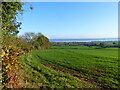
A hedge, a field, and the River Severn beyond, High Woolaston, Gloucestershire
Image: © Ruth Sharville
Taken: 13 Nov 2022
0.14 miles
3
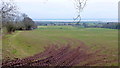
Pastoral scene to the mighty Severn
View from Park Hill Road over High Woolaston.
Image: © Jonathan Billinger
Taken: 8 Feb 2012
0.15 miles
4
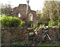
Park Hill Baptist Chapel ruins
The inscription says it was built in 1835 - now roofless. The Victoria County History series: A History of the County of Gloucester, Volume 5: Bledisloe Hundred, St Briavels Hundred, The Forest of Dean (1996), pp.117-118 (Woolaston - Nonconformity) records that the chapel was still well attended into the 1920s, but the last burial there took place in 1906, and the building was closed about 1955. One of my churches and chapels series - which I have visited from home by bike.
Image: © Andy Stott
Taken: 21 Mar 2020
0.22 miles