IMAGES TAKEN NEAR TO
Woodside, LYDNEY, GL15 6PS
Introduction
This page details the photographs taken nearby to Woodside, GL15 6PS by members of the Geograph project.
The Geograph project started in 2005 with the aim of publishing, organising and preserving representative images for every square kilometre of Great Britain, Ireland and the Isle of Man.

There are currently over 7.5m images from over14,400 individuals and you can help contribute to the project by visiting https://www.geograph.org.uk
Image Map
Images are licensed for reuse under creativecommons.org/licenses/by-sa/2.0
Notes
- Clicking on the map will re-center to the selected point.
- The higher the marker number, the further away the image location is from the centre of the postcode.
Image Listing (2 Images Found)
Images are licensed for reuse under creativecommons.org/licenses/by-sa/2.0
Image
Details
Distance
1
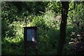
Notice board by the Gloucestershire Way
This board describes the history of the adjacent lime kiln wood (dating from 1131), information about the local fauna and flora, and details of a dormouse project in the wood. I understand that the wood was purchased by a benefactor specifically to preserve one of the few remaining local habitats of these little creatures.
Image: © Pat Macleod
Taken: 31 Aug 2010
0.16 miles
2
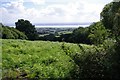
View South East from The Tumps towards the Severn
Image: © Pat Macleod
Taken: 31 Aug 2010
0.19 miles