IMAGES TAKEN NEAR TO
Netherend, LYDNEY, GL15 6PH
Introduction
This page details the photographs taken nearby to Netherend, GL15 6PH by members of the Geograph project.
The Geograph project started in 2005 with the aim of publishing, organising and preserving representative images for every square kilometre of Great Britain, Ireland and the Isle of Man.

There are currently over 7.5m images from over14,400 individuals and you can help contribute to the project by visiting https://www.geograph.org.uk
Image Map
Images are licensed for reuse under creativecommons.org/licenses/by-sa/2.0
Notes
- Clicking on the map will re-center to the selected point.
- The higher the marker number, the further away the image location is from the centre of the postcode.
Image Listing (57 Images Found)
Images are licensed for reuse under creativecommons.org/licenses/by-sa/2.0
Image
Details
Distance
1
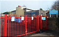
Woolaston Under 5s
Located at the SE edge of Woolaston Primary School. http://www.geograph.org.uk/photo/3230780
The following notes are based on information shown on the Woolaston Under 5s' website.
Woolaston Under 5s was set up in the village hall in the 1970s to serve local children. After relocation for a while to the nearby village of Alvington, the Under 5s site is now here, a state of the art surestart building which was designed specifically for playgroup use.
As a community playgroup, Woolaston Under 5s is a non-profit-making organisation run by a voluntary committee of parents and carers whose children attend the playgroup.
Image: © Jaggery
Taken: 18 Nov 2012
0.02 miles
2
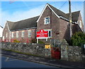
Woolaston Primary School
There are about 160 children (ages 4-11) enrolled at the school,
which is located in the Netherend area of Woolaston.
Image: © Jaggery
Taken: 18 Nov 2012
0.04 miles
3
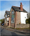
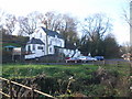
Netherend Inn, Woolaston
Located in the Netherend area of the civil parish of Woolaston.
Image: © Jaggery
Taken: 18 Nov 2012
0.08 miles
4
Woolaston Memorial Hall
Located at the eastern end of the residential street Swains Field. This memorial hall and community centre was officially opened on May 1st 2006. It replaced the first memorial hall, opened in July 1961.
Image: © Jaggery
Taken: 18 Nov 2012
0.09 miles
5
Woolaston boundary sign
The boundary sign is located NW of the A48, between the turnings for Perry Field behind the camera and Ashway ahead. Confusingly, for this visitor at least, the sign shows Woolaston but the area ahead is Netherend. The explanation is that Woolaston is both a village and a civil parish (in the Forest of Dean district of Gloucestershire). Netherend is part of the civil parish of Woolaston, which also includes many other hamlets and small villages, including Stroat, Woolaston Common, High Woolaston, Woolaston Woodside and Woolaston Slade.
Image: © Jaggery
Taken: 18 Nov 2012
0.09 miles

8
Children's play area near Woolaston Memorial Hall
The play area is between the hall http://www.geograph.org.uk/photo/3231035 and a recreation field.
Image: © Jaggery
Taken: 18 Nov 2012
0.11 miles
9
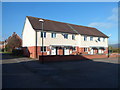
Swains Field houses, Woolaston
These houses face Woolaston Memorial Hall. http://www.geograph.org.uk/photo/3231035
Image: © Jaggery
Taken: 18 Nov 2012
0.11 miles