IMAGES TAKEN NEAR TO
Woodside, LYDNEY, GL15 6PB
Introduction
This page details the photographs taken nearby to Woodside, GL15 6PB by members of the Geograph project.
The Geograph project started in 2005 with the aim of publishing, organising and preserving representative images for every square kilometre of Great Britain, Ireland and the Isle of Man.

There are currently over 7.5m images from over14,400 individuals and you can help contribute to the project by visiting https://www.geograph.org.uk
Image Map
Images are licensed for reuse under creativecommons.org/licenses/by-sa/2.0
Notes
- Clicking on the map will re-center to the selected point.
- The higher the marker number, the further away the image location is from the centre of the postcode.
Image Listing (9 Images Found)
Images are licensed for reuse under creativecommons.org/licenses/by-sa/2.0
Image
Details
Distance
1
Bible Chapel, Woolaston Woodside
Churches and chapels (no 2). Apparently founded in 1836, the first Christian Bible Chapel in west Gloucestershire. Closed in 1959.
Image: © Andy Stott
Taken: 8 Jan 2012
0.06 miles
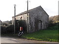
2
A former chapel?
Not sure if this is a former chapel near Woolaston or simply a farm building resembling a chapel.
Image: © Philip Halling
Taken: 25 Oct 2014
0.07 miles
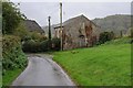
3
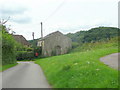
Ex-chapel at Woolaston Woodside
Evidence suggests a previous religious use for this building at Woolaston Woodside.
Image: © Jonathan Billinger
Taken: 27 Aug 2010
0.08 miles
4
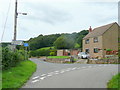
Lane junction
At Woolaston Woodside.
Image: © Jonathan Billinger
Taken: 27 Aug 2010
0.11 miles
5
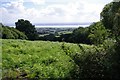
View South East from The Tumps towards the Severn
Image: © Pat Macleod
Taken: 31 Aug 2010
0.12 miles
6
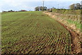
New crops in October
The day I took this was the first day of the clocks having gone back. This was a cheering sight, given the lovely day was to end too soon.
Image: © Ruth Sharville
Taken: 26 Oct 2008
0.17 miles
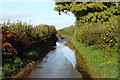
7
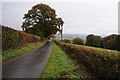
The route of the Gloucestershire Way
The long distance path, The Gloucestershire Way follows this road at Woolaston Woodside.
Image: © Philip Halling
Taken: 25 Oct 2014
0.20 miles
8
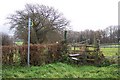
Footpath sign and stile.
The path heads south-east towards the Severn.
Image: © Jonathan Billinger
Taken: 4 Dec 2006
0.21 miles
9
After a downpour
The road here, just approaching its highest point, is part of the Gloucestershire Way footpath.
Image: © Ruth Sharville
Taken: 26 Oct 2008
0.24 miles