IMAGES TAKEN NEAR TO
Ring Fence, LYDNEY, GL15 6NX
Introduction
This page details the photographs taken nearby to Ring Fence, GL15 6NX by members of the Geograph project.
The Geograph project started in 2005 with the aim of publishing, organising and preserving representative images for every square kilometre of Great Britain, Ireland and the Isle of Man.

There are currently over 7.5m images from over14,400 individuals and you can help contribute to the project by visiting https://www.geograph.org.uk
Image Map
Images are licensed for reuse under creativecommons.org/licenses/by-sa/2.0
Notes
- Clicking on the map will re-center to the selected point.
- The higher the marker number, the further away the image location is from the centre of the postcode.
Image Listing (13 Images Found)
Images are licensed for reuse under creativecommons.org/licenses/by-sa/2.0
Image
Details
Distance
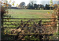
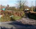
1
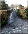
Northern side of Ring Fence, Woolaston Common
Ring Fence is a lane which follows a roughly rectangular course
(along three sides of a rectangle, roughly).
Its other end http://www.geograph.org.uk/photo/3231219 is about 240 metres to the SE (left).
Image: © Jaggery
Taken: 18 Nov 2012
0.10 miles
2
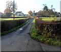
Ring Fence, Woolaston Common
Viewed from Woolaston Common. This is the southern side of a lane named Ring Fence, which follows
a roughly rectangular course (along three sides of a rectangle, roughly)
before rejoining Woolaston Common about 240 metres NW http://www.geograph.org.uk/photo/3231241 of this junction.
Image: © Jaggery
Taken: 18 Nov 2012
0.10 miles
3
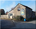
The Rising Sun, Woolaston Common
From this side, the pub looks quite small, but that is not the case. http://www.geograph.org.uk/photo/3231228
Image: © Jaggery
Taken: 18 Nov 2012
0.11 miles
4
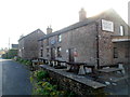
The Rising Sun, Woolaston Common viewed from the NW
This view shows a large pub, in contrast to the false impression
given by the view from the SE. http://www.geograph.org.uk/photo/3231225
Image: © Jaggery
Taken: 18 Nov 2012
0.12 miles
5
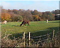
Llamas, Woolaston Common
The llamas are grazing in a field opposite The Rising Sun. http://www.geograph.org.uk/photo/3231225
Image: © Jaggery
Taken: 18 Nov 2012
0.14 miles
6
Ornate field gate, Woolaston Common
I don't recall seeing a field gate like this one, which has metal tracery along its top bar.
Image: © Jaggery
Taken: 18 Nov 2012
0.15 miles
7
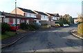
Birchwood Road houses, Woolaston
Viewed from the corner of Oak Crescent.
Image: © Jaggery
Taken: 18 Nov 2012
0.15 miles
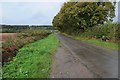
9
Brooklet Road, Woolaston Common
Brooklet Road is not a through road. It leads to Rose Cottage, Yewtree Cottage
and Brooklet, a house at the edge of an unnamed brooklet.
Image: © Jaggery
Taken: 18 Nov 2012
0.18 miles
10
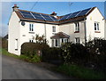
Solar panels, Woolaston Common
I'd guess that even the low angle of the mid-November midday sun at latitude 51 north
is enough to generate some usable energy on a sunny day.
Image: © Jaggery
Taken: 18 Nov 2012
0.20 miles