IMAGES TAKEN NEAR TO
Reddings Close, LYDNEY, GL15 6NR
Introduction
This page details the photographs taken nearby to Reddings Close, GL15 6NR by members of the Geograph project.
The Geograph project started in 2005 with the aim of publishing, organising and preserving representative images for every square kilometre of Great Britain, Ireland and the Isle of Man.

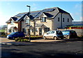
There are currently over 7.5m images from over14,400 individuals and you can help contribute to the project by visiting https://www.geograph.org.uk
Image Map
Images are licensed for reuse under creativecommons.org/licenses/by-sa/2.0
Notes
- Clicking on the map will re-center to the selected point.
- The higher the marker number, the further away the image location is from the centre of the postcode.
Image Listing (24 Images Found)
Images are licensed for reuse under creativecommons.org/licenses/by-sa/2.0
Image
Details
Distance
1
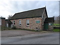
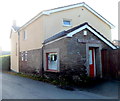
Woolaston Methodist Church
Churches and chapels. No. 51. My aim is to cycle to all the churches within 25 km of my home.
Image: © Andy Stott
Taken: 26 Dec 2015
0.13 miles
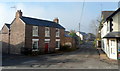
2
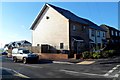
Corner of Severn View Road and Bridge View, Netherend, Woolaston
The corner house, and the houses on the left, http://www.geograph.org.uk/photo/3231023 were built in 2012.
Image: © Jaggery
Taken: 18 Nov 2012
0.13 miles
3
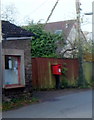
Large postbox outside tiny Netherend post office, Woolaston
There is an interesting contrast in the sizes of the postbox and post office. http://www.geograph.org.uk/photo/3231117
Image: © Jaggery
Taken: 18 Nov 2012
0.14 miles
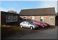
4
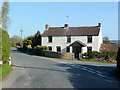
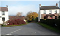
Cottage in Netherend
At the junction of Woolaston Common (left) and Spout Hill.
Image: © Jonathan Billinger
Taken: 16 Apr 2010
0.14 miles
5
New houses, Bridge View, Netherend, Woolaston
These houses were built in 2012, on the south side of Severn View Road.
Image: © Jaggery
Taken: 18 Nov 2012
0.14 miles
6
Woolaston Methodist Church
Located in Woolaston Common.
Image: © Jaggery
Taken: 18 Nov 2012
0.14 miles
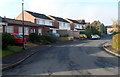
7
Severn View Road, Netherend, Woolaston
Severn View Road heads west past Netherend Stores http://www.geograph.org.uk/photo/3230997 on the right and Roseville on the left.
The location is the Netherend area of the civil parish of Woolaston.
Image: © Jaggery
Taken: 18 Nov 2012
0.14 miles
8
Birchwood Road houses, Woolaston
Viewed from the corner of Oak Crescent.
Image: © Jaggery
Taken: 18 Nov 2012
0.14 miles
9
Netherend Post Office, Woolaston
The tiny size of the single-storey post office contrasts with the "beefy" postbox outside. http://www.geograph.org.uk/photo/3231123
Image: © Jaggery
Taken: 18 Nov 2012
0.15 miles
10
Spout Hill, Woolaston
Spout Hill heads away from Netherend towards Beanhill.
Image: © Jaggery
Taken: 18 Nov 2012
0.15 miles