IMAGES TAKEN NEAR TO
Pastors Hill, LYDNEY, GL15 6NA
Introduction
This page details the photographs taken nearby to Pastors Hill, GL15 6NA by members of the Geograph project.
The Geograph project started in 2005 with the aim of publishing, organising and preserving representative images for every square kilometre of Great Britain, Ireland and the Isle of Man.

There are currently over 7.5m images from over14,400 individuals and you can help contribute to the project by visiting https://www.geograph.org.uk
Image Map
Images are licensed for reuse under creativecommons.org/licenses/by-sa/2.0
Notes
- Clicking on the map will re-center to the selected point.
- The higher the marker number, the further away the image location is from the centre of the postcode.
Image Listing (6 Images Found)
Images are licensed for reuse under creativecommons.org/licenses/by-sa/2.0
Image
Details
Distance
2
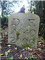
Boundary Stone, Bream Eaves
A Royal Forest of Dean BS, just North of a track near a property called "Baytree", on land owned by "Forestry England" (aka Forestry Commission).
Inscription: D. F. / Nᴼ. 40 / 2006
Milestone Society National ID: GL_DFWDEA40em
Image: © Mr Red
Taken: 15 May 2023
0.07 miles
5
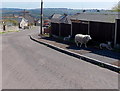
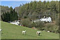
Shady sheep in Bream
When the sun is high and you're wearing a woolly coat you can't take off, the shade of a fence in Lansdown Walk will do.
Image: © Jaggery
Taken: 6 May 2013
0.24 miles
6
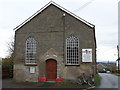
Victory Church, Bream
Churches and chapels (no 44). This chapel has a varied history. It was built as a Wesleyan Chapel in 1860. It became part of the Methodist Church in 1932, closed in 1959 and was used by a pentecostalist church in 1992. It became home to the Victory Church in 2010.
Image: © Andy Stott
Taken: 9 Nov 2013
0.25 miles