IMAGES TAKEN NEAR TO
Hillside Close, LYDNEY, GL15 6LU
Introduction
This page details the photographs taken nearby to Hillside Close, GL15 6LU by members of the Geograph project.
The Geograph project started in 2005 with the aim of publishing, organising and preserving representative images for every square kilometre of Great Britain, Ireland and the Isle of Man.

There are currently over 7.5m images from over14,400 individuals and you can help contribute to the project by visiting https://www.geograph.org.uk
Image Map
Images are licensed for reuse under creativecommons.org/licenses/by-sa/2.0
Notes
- Clicking on the map will re-center to the selected point.
- The higher the marker number, the further away the image location is from the centre of the postcode.
Image Listing (21 Images Found)
Images are licensed for reuse under creativecommons.org/licenses/by-sa/2.0
Image
Details
Distance
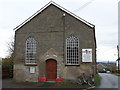
1
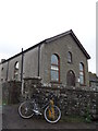
Mount Zion Primitive Methodist Chapel, Bream
Churches and chapels (no. 45). The chapel was built in 1858. It is now the Eaves Christian Centre.
Image: © Andy Stott
Taken: 9 Nov 2013
0.06 miles
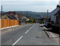
2
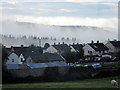
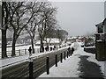
Early morning mist over housing estate
Image: © John H Darch
Taken: 28 Aug 2020
0.13 miles
3
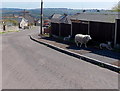
Shady sheep in Bream
When the sun is high and you're wearing a woolly coat you can't take off, the shade of a fence in Lansdown Walk will do.
Image: © Jaggery
Taken: 6 May 2013
0.16 miles
5
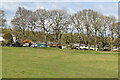
Whitecroft Road, Bream
Looking east from the corner of Parkend Road.
Image: © Jaggery
Taken: 6 May 2013
0.18 miles
6
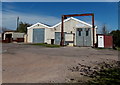
Frank Luther, Bream
Car body repairs business set back 20 metres from Lansdown Walk.
Image: © Jaggery
Taken: 6 May 2013
0.19 miles
7
Victory Church, Bream
Churches and chapels (no 44). This chapel has a varied history. It was built as a Wesleyan Chapel in 1860. It became part of the Methodist Church in 1932, closed in 1959 and was used by a pentecostalist church in 1992. It became home to the Victory Church in 2010.
Image: © Andy Stott
Taken: 9 Nov 2013
0.19 miles
8
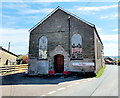
Victory Church, Bream
Viewed across Brockhollands Road. The church used to be the Christian Gospel Church.
The inscription on the tablet on the wall shows WESLEYAN CHAPEL 1860.
Image: © Jaggery
Taken: 6 May 2013
0.19 miles
9
Bream in winter
Taken on the afternoon of 5th February 2009
Image: © Barry Mizen
Taken: 5 Feb 2009
0.22 miles
10
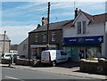
Boots Pharmacy in Bream
Located in Fir Tree Cottage, 1 High Street.
Image: © Jaggery
Taken: 6 May 2013
0.22 miles