IMAGES TAKEN NEAR TO
Woodland Road, LYDNEY, GL15 6LP
Introduction
This page details the photographs taken nearby to Woodland Road, GL15 6LP by members of the Geograph project.
The Geograph project started in 2005 with the aim of publishing, organising and preserving representative images for every square kilometre of Great Britain, Ireland and the Isle of Man.

There are currently over 7.5m images from over14,400 individuals and you can help contribute to the project by visiting https://www.geograph.org.uk
Image Map
Images are licensed for reuse under creativecommons.org/licenses/by-sa/2.0
Notes
- Clicking on the map will re-center to the selected point.
- The higher the marker number, the further away the image location is from the centre of the postcode.
Image Listing (43 Images Found)
Images are licensed for reuse under creativecommons.org/licenses/by-sa/2.0
Image
Details
Distance
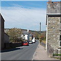
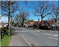
1

The view north from Bream Cenotaph
Taken in November 2007 and not in any way digitally altered. These are "those blue remembered hills"
Image: © Hugh Savell
Taken: 17 Nov 2007
0.06 miles
2
Oakwood Road WNW of Sun Green Road, Bream
Looking towards the Mill Hill area.
Image: © Jaggery
Taken: 6 May 2013
0.09 miles
3
Oakwood Road near the corner of Sun Green Close, Bream
The left turn is for Sun Green Close. http://www.geograph.org.uk/photo/3809481
Image: © Jaggery
Taken: 6 May 2013
0.11 miles
4
Sun Green Close, Bream
Viewed across Oakwood Road.
Image: © Jaggery
Taken: 6 May 2013
0.12 miles
5
Hang Hill Road, Bream
Viewed across Oakwood Road from the corner of Sun Green Road.
Image: © Jaggery
Taken: 6 May 2013
0.13 miles
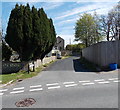
6
Oakwood Road, Bream
Viewed from the corner of High Street. Bream C of E Primary School is on the right.
Image: © Jaggery
Taken: 6 May 2013
0.13 miles
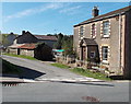
7
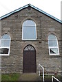
Bible Christian Chapel, Bream
Churches and chapels (no. 46). The new chapel was built in 1906 adjacent to the old one, which became the school room. The chapel closed in 2012.
Image: © Andy Stott
Taken: 9 Nov 2013
0.14 miles
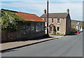
8
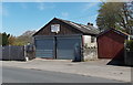
JC Autos in Bream
Garage in Oakwood Road, near the corner of Hang Hill Road.
Image: © Jaggery
Taken: 6 May 2013
0.14 miles
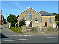
9
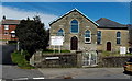
Bream Methodist Church
Viewed across Parkend Road from the corner of Whitecroft Road in May 2013. At the January 2014 date of this upload to Geograph, the West Dean Parish Council website was showing that Bream Methodist Church has moved its centre of worship to the West Dean Centre http://www.geograph.org.uk/photo/3809485 on a permanent basis.
Image: © Jaggery
Taken: 6 May 2013
0.14 miles
10
Bream Methodist Church
On the corner of Parkend Road (right) and the lane through to Hang Hill.
Image: © Jonathan Billinger
Taken: 13 Oct 2009
0.15 miles