IMAGES TAKEN NEAR TO
The Tufts, LYDNEY, GL15 6HN
Introduction
This page details the photographs taken nearby to The Tufts, GL15 6HN by members of the Geograph project.
The Geograph project started in 2005 with the aim of publishing, organising and preserving representative images for every square kilometre of Great Britain, Ireland and the Isle of Man.

There are currently over 7.5m images from over14,400 individuals and you can help contribute to the project by visiting https://www.geograph.org.uk
Image Map
Images are licensed for reuse under creativecommons.org/licenses/by-sa/2.0
Notes
- Clicking on the map will re-center to the selected point.
- The higher the marker number, the further away the image location is from the centre of the postcode.
Image Listing (3 Images Found)
Images are licensed for reuse under creativecommons.org/licenses/by-sa/2.0
Image
Details
Distance
1
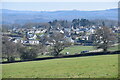
View over Bream
New Road can be seen descending the hill just to the right of centre.
Image: © David Martin
Taken: 3 Apr 2022
0.13 miles
2
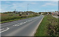
B4231 heads out of Bream
Near the SW edge of Bream, the B4231 heads towards Coleford.
Image: © Jaggery
Taken: 6 May 2013
0.16 miles
3
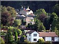
Mill Hill, Bream
Mill Hill, Bream on a September afternoon.
Image: © Forester
Taken: 23 Sep 2006
0.23 miles