IMAGES TAKEN NEAR TO
Lydney Road, LYDNEY, GL15 6ER
Introduction
This page details the photographs taken nearby to Lydney Road, GL15 6ER by members of the Geograph project.
The Geograph project started in 2005 with the aim of publishing, organising and preserving representative images for every square kilometre of Great Britain, Ireland and the Isle of Man.

There are currently over 7.5m images from over14,400 individuals and you can help contribute to the project by visiting https://www.geograph.org.uk
Image Map
Images are licensed for reuse under creativecommons.org/licenses/by-sa/2.0
Notes
- Clicking on the map will re-center to the selected point.
- The higher the marker number, the further away the image location is from the centre of the postcode.
Image Listing (7 Images Found)
Images are licensed for reuse under creativecommons.org/licenses/by-sa/2.0
Image
Details
Distance
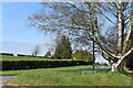
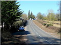
2
Layby at the southern edge of Bream
The B4231 from Lydney reaches Bream, a large village (population c3,000)
in the Forest of Dean, Gloucestershire.
Image: © Jaggery
Taken: 6 May 2013
0.10 miles
3
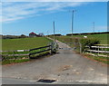
Access lane to Kingsmoor Farm, Bream
Viewed from the B4231 Lydney Road.
Image: © Jaggery
Taken: 6 May 2013
0.12 miles
4
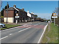
Start of the 30mph zone in Bream
The B4231 from Lydney passed the Bream boundary sign http://www.geograph.org.uk/photo/3446680 about 700 metres behind the camera.
These are the first roadside houses on the south side of the village, so the National Speed Limit reduces to 30mph ahead.
Image: © Jaggery
Taken: 6 May 2013
0.17 miles
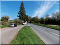
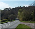
5
B4231, towards Bream
Looking north-west on a bright March morning.
Image: © Jonathan Billinger
Taken: 8 Mar 2010
0.18 miles
6
Road from Bream to Lydney
Viewed from the edge of a layby http://www.geograph.org.uk/photo/3446680 at the southern edge of Bream.
The B4231 heads south through the Forest of Dean towards Lydney.
Image: © Jaggery
Taken: 6 May 2013
0.22 miles
7
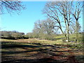
Rough pasture land
Old mining territory to the south of Bream.
Image: © Jonathan Billinger
Taken: 8 Mar 2010
0.23 miles