IMAGES TAKEN NEAR TO
Lower Common, LYDNEY, GL15 6DY
Introduction
This page details the photographs taken nearby to Lower Common, GL15 6DY by members of the Geograph project.
The Geograph project started in 2005 with the aim of publishing, organising and preserving representative images for every square kilometre of Great Britain, Ireland and the Isle of Man.

There are currently over 7.5m images from over14,400 individuals and you can help contribute to the project by visiting https://www.geograph.org.uk
Image Map
Images are licensed for reuse under creativecommons.org/licenses/by-sa/2.0
Notes
- Clicking on the map will re-center to the selected point.
- The higher the marker number, the further away the image location is from the centre of the postcode.
Image Listing (6 Images Found)
Images are licensed for reuse under creativecommons.org/licenses/by-sa/2.0
Image
Details
Distance
1
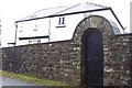
Heaven's Gate.
Actually the name of the house.
Image: © Jonathan Billinger
Taken: 4 Dec 2006
0.02 miles
2
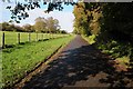
Lodge Lane
Lodge Lane to the north of Aylburton.
Image: © Philip Halling
Taken: 25 Oct 2014
0.13 miles
3
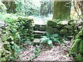
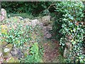
Stone Stile, Aylburton
On Gloucestershire footpath FAY4 looking NW, the view back is Image
The wall on the left in the northern border of Meend Plantation and the border between Aylburton and Alvington parishes.
Image: © Mr Red
Taken: 26 Aug 2024
0.14 miles
4
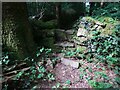
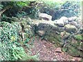
Stone Stile, Aylburton
On Gloucestershire footpath FAY4 looking SE, the view back is Image
The wall on the right is the northern border of Meend Plantation and the border between Aylburton and Alvington parishes.
Image: © Mr Red
Taken: 26 Aug 2024
0.14 miles
5
Stone Stile, Aylburton
On Gloucestershire footpath FAY4 looking South, the view from the other side is Image
The wall on the right is the border between Aylburton and Alvington parishes.
Image: © Mr Red
Taken: 26 Aug 2024
0.19 miles
6
Stone Stile, Aylburton
On Gloucestershire footpath FAY4 looking NW, the view from the other side is Image
The wall on the right is the border between Aylburton and Alvington parishes.
Image: © Mr Red
Taken: 26 Aug 2024
0.19 miles