IMAGES TAKEN NEAR TO
Sandford Road, LYDNEY, GL15 6DP
Introduction
This page details the photographs taken nearby to Sandford Road, GL15 6DP by members of the Geograph project.
The Geograph project started in 2005 with the aim of publishing, organising and preserving representative images for every square kilometre of Great Britain, Ireland and the Isle of Man.

There are currently over 7.5m images from over14,400 individuals and you can help contribute to the project by visiting https://www.geograph.org.uk
Image Map
Images are licensed for reuse under creativecommons.org/licenses/by-sa/2.0
Notes
- Clicking on the map will re-center to the selected point.
- The higher the marker number, the further away the image location is from the centre of the postcode.
Image Listing (9 Images Found)
Images are licensed for reuse under creativecommons.org/licenses/by-sa/2.0
Image
Details
Distance
1
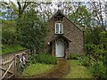
Aylburton Common Church
Established as a mission room by the lay preacher Frederick Bryan in 1867. One of the churches and chapels within 25km of my home that I am visiting by bike.
Image: © Andy Stott
Taken: 22 May 2021
0.18 miles
2
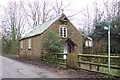
Aylburton Common Mission Church
Built in 1867 this small building is still functioning as a place of worship.
Image: © Jonathan Billinger
Taken: 4 Dec 2006
0.19 miles

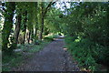
4
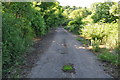
Looking along a disused section of the A48
Image: © Nick Mutton 01329 000000
Taken: 16 Jun 2010
0.21 miles
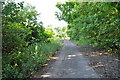
5
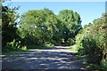
Looking along a disused section of the A48
Image: © Nick Mutton 01329 000000
Taken: 16 Jun 2010
0.22 miles
6
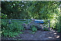
Gate across disused section of A48 leading to Sewage works
Image: © Nick Mutton 01329 000000
Taken: 16 Jun 2010
0.22 miles
8
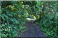
Disused section of the A48
Image: © Nick Mutton 01329 000000
Taken: 16 Jun 2010
0.24 miles