IMAGES TAKEN NEAR TO
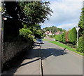
Chapel Hill, LYDNEY, GL15 6DF
Introduction
This page details the photographs taken nearby to Chapel Hill, GL15 6DF by members of the Geograph project.
The Geograph project started in 2005 with the aim of publishing, organising and preserving representative images for every square kilometre of Great Britain, Ireland and the Isle of Man.

There are currently over 7.5m images from over14,400 individuals and you can help contribute to the project by visiting https://www.geograph.org.uk
Image Map
Images are licensed for reuse under creativecommons.org/licenses/by-sa/2.0
Notes
- Clicking on the map will re-center to the selected point.
- The higher the marker number, the further away the image location is from the centre of the postcode.
Image Listing (118 Images Found)
Images are licensed for reuse under creativecommons.org/licenses/by-sa/2.0
Image
Details
Distance
1
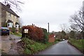
Approaching Aylburton village from the north.
Image: © Jonathan Billinger
Taken: 4 Dec 2006
0.13 miles
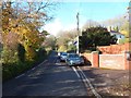
2
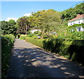
Church Road, Aylburton
Church Road ascends away from Aylburton past houses at the northwest edge of the village.
Image: © Jaggery
Taken: 18 Sep 2016
0.15 miles
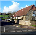
3
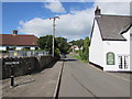
Chapel Hill, Aylburton
Ascending from the A48 High Street past The Cross pub http://www.geograph.org.uk/photo/5473722 on the right.
Image: © Jaggery
Taken: 18 Sep 2016
0.15 miles
4
NW along Chapel Hill, Aylburton, Gloucestershire
Looking to the NW along Chapel Hill from the corner of the A48 High Street.
Pointing this way, a nearby sign shows Upper Common 1 (mile)
Image: © Jaggery
Taken: 22 Oct 2023
0.16 miles
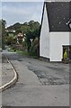
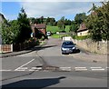
5
Chapel Hill, Aylburton
Viewed from near the High Street junction. The car is nearly opposite the Orchard Close junction.
Image: © Jaggery
Taken: 18 Sep 2016
0.17 miles
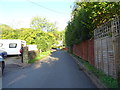
6
End of the 30mph speed limit, Church Road, Aylburton
A view NW along Church Road looking away from the centre of the village towards Aylburton Common. The round white road sign with a diagonal black line marks the end of the 30mph zone in the village and the start of the National Speed Limit zone ahead.
Image: © Jaggery
Taken: 18 Nov 2012
0.17 miles
7
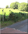
Stile to a public footpath across a field, Aylburton
From Church Road.
Image: © Jaggery
Taken: 18 Sep 2016
0.17 miles
9
Cross Farm Close, Aylburton
A short cul-de-sac viewed across High Street (the A48).
Image: © Jaggery
Taken: 18 Nov 2012
0.17 miles
10
Cross Farm Close, Aylburton
Cul-de-sac viewed across the A48 High Street.
Image: © Jaggery
Taken: 18 Sep 2016
0.17 miles