IMAGES TAKEN NEAR TO
High Street, LYDNEY, GL15 6DA
Introduction
This page details the photographs taken nearby to High Street, GL15 6DA by members of the Geograph project.
The Geograph project started in 2005 with the aim of publishing, organising and preserving representative images for every square kilometre of Great Britain, Ireland and the Isle of Man.

There are currently over 7.5m images from over14,400 individuals and you can help contribute to the project by visiting https://www.geograph.org.uk
Image Map
Images are licensed for reuse under creativecommons.org/licenses/by-sa/2.0
Notes
- Clicking on the map will re-center to the selected point.
- The higher the marker number, the further away the image location is from the centre of the postcode.
Image Listing (171 Images Found)
Images are licensed for reuse under creativecommons.org/licenses/by-sa/2.0
Image
Details
Distance
1
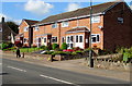
Brick houses in Aylburton
Viewed across the A48 High Street, the main road through the village.
Image: © Jaggery
Taken: 18 Sep 2016
0.00 miles
2

High Street, Aylburton
A view west along the A48, here named High Street, Aylburton.
Image: © Jaggery
Taken: 18 Nov 2012
0.01 miles
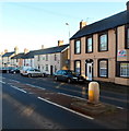
3
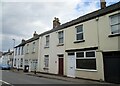
Terraced houses, High Street, Aylburton
Image: © Jonathan Thacker
Taken: 26 May 2021
0.02 miles
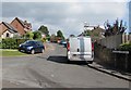
4
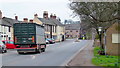
High Street, Aylburton
The truck is approaching the school crossing with appropriate caution.
Image: © Jonathan Billinger
Taken: 8 Feb 2012
0.02 miles
5
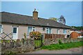
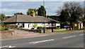
Aylburton : Bungalows
Bungalows off the High Street.
Image: © Lewis Clarke
Taken: 22 Mar 2023
0.02 miles
6
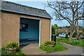
Aylburton : Bus Shelter
A bus stop on the High Street.
Image: © Lewis Clarke
Taken: 22 Mar 2023
0.02 miles
7

Tree-flanked High Street bus shelter, Aylburton
The shelter is alongside the bus route from Chepstow to Lydney (part of the A48).
Image: © Jaggery
Taken: 18 Nov 2012
0.03 miles
8
High Street bungalows and bus shelter, Aylburton
The shelter is alongside a bus stop for buses to Lydney.
Image: © Jaggery
Taken: 18 Sep 2016
0.03 miles
9
South side of High Street, Aylburton
Looking east along the A48, here named High Street, Aylburton.
This part of High Street is between the Church Road junction and the Millbrook Green junction.
Image: © Jaggery
Taken: 18 Nov 2012
0.03 miles
10
Up Milling Crescent Aylburton
Milling Crescent ascends from Church Street.
Image: © Jaggery
Taken: 18 Sep 2016
0.03 miles