IMAGES TAKEN NEAR TO
Church Lane, LYDNEY, GL15 6BQ
Introduction
This page details the photographs taken nearby to Church Lane, GL15 6BQ by members of the Geograph project.
The Geograph project started in 2005 with the aim of publishing, organising and preserving representative images for every square kilometre of Great Britain, Ireland and the Isle of Man.

There are currently over 7.5m images from over14,400 individuals and you can help contribute to the project by visiting https://www.geograph.org.uk
Image Map
Images are licensed for reuse under creativecommons.org/licenses/by-sa/2.0
Notes
- Clicking on the map will re-center to the selected point.
- The higher the marker number, the further away the image location is from the centre of the postcode.
Image Listing (93 Images Found)
Images are licensed for reuse under creativecommons.org/licenses/by-sa/2.0
Image
Details
Distance

2
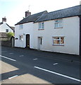
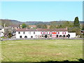
White houses, Main Road, Alvington
Viewed across the A48, here named Main Road. Conifer Cottage is on the left.
The short white lines on the road are near a speed camera https://www.geograph.org.uk/photo/5854823 out of shot on the left.
Image: © Jaggery
Taken: 18 Sep 2016
0.05 miles
3
Main Road speed camera, Alvington
Alongside the A48, here named Main Road.
Image: © Jaggery
Taken: 18 Sep 2016
0.05 miles
4
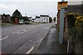
Speed camera in Alvington
Speed camera on the A48 passing through the village of Alvington. In the background is the former Globe public house.
Image: © Philip Halling
Taken: 25 Oct 2014
0.05 miles
5
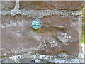
Ordnance Survey Cut Mark with Bolt
This badly weathered cut mark with its remaining bolt can be found on the wall of St Thomas's Church in Alvington.
For more detail see : http://www.bench-marks.org.uk/bm45897
Image: © Peter Wood
Taken: 16 Oct 2016
0.06 miles
6
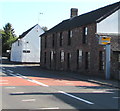
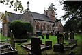
View to the Blacksmith's Arms, Alvington
Photo taken from the north corner of St. Andrew's churchyard.
Image: © Jonathan Billinger
Taken: 8 Apr 2010
0.06 miles
7
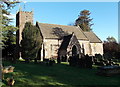
South side of St Andrew's Church, Alvington
The church has 12th century origins, though almost all of the present-day church dates from major restorations in the 19th century.
Image: © Jaggery
Taken: 1 Jan 2013
0.06 miles
8
Alvington church
Dating from 1140, the church was originally named St. Mary’s, in 1523 it changed to its current name of St. Andrew’s. In the 1850s the church was restored.
Image: © Philip Halling
Taken: 25 Oct 2014
0.06 miles
9
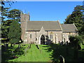
The Church of St Andrew in Alvington
Viewed from the south.
Image: © Peter Wood
Taken: 16 Oct 2016
0.06 miles
10
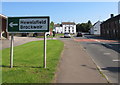
Hewelsfield and Brockweir direction side in Alvington
Alongside the A48 Main Road on the approach to the Clanna Road junction.
Image: © Jaggery
Taken: 18 Sep 2016
0.06 miles