IMAGES TAKEN NEAR TO
Brook Lane, LYDNEY, GL15 6BP
Introduction
This page details the photographs taken nearby to Brook Lane, GL15 6BP by members of the Geograph project.
The Geograph project started in 2005 with the aim of publishing, organising and preserving representative images for every square kilometre of Great Britain, Ireland and the Isle of Man.

There are currently over 7.5m images from over14,400 individuals and you can help contribute to the project by visiting https://www.geograph.org.uk
Image Map
Images are licensed for reuse under creativecommons.org/licenses/by-sa/2.0
Notes
- Clicking on the map will re-center to the selected point.
- The higher the marker number, the further away the image location is from the centre of the postcode.
Image Listing (9 Images Found)
Images are licensed for reuse under creativecommons.org/licenses/by-sa/2.0
Image
Details
Distance
1
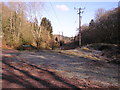
Power lines through the forest
Looking towards the North West.
Image: © Stuart Wilding
Taken: 10 Feb 2006
0.04 miles
2

The view north from Bream Cenotaph
Taken in November 2007 and not in any way digitally altered. These are "those blue remembered hills"
Image: © Hugh Savell
Taken: 17 Nov 2007
0.12 miles
3
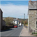
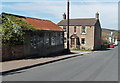
Oakwood Road WNW of Sun Green Road, Bream
Looking towards the Mill Hill area.
Image: © Jaggery
Taken: 6 May 2013
0.19 miles
4
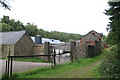
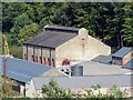
The former Flour Mill Colliery
This well hidden site contains listed buildings from a former colliery and now houses a well-renowned railway locomotive repair shop and a firm selling lubricating oil. The locomotive repair business does not advertise itself on the access road and casual visitors are not welcome.
Image: © Chris Allen
Taken: 6 Sep 2009
0.20 miles
5
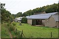
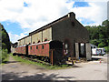
Former Flour Mill Colliery, Bream
Now home to a lubricating oil company (building closest) and a well known steam locomotive repair company. The jib of a large Ransomes & Rapier steam breakdown crane is visible.
Image: © Chris Allen
Taken: 6 Sep 2009
0.22 miles
6
The Flour Mill
The site of the former Flour Mill Colliery.
Image: © Forester
Taken: 23 Sep 2006
0.23 miles
7
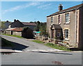
Oakwood Road near the corner of Sun Green Close, Bream
The left turn is for Sun Green Close. http://www.geograph.org.uk/photo/3809481
Image: © Jaggery
Taken: 6 May 2013
0.24 miles
8
The Flour Mill
Seen during its 20th anniversary open day, the Flour Mill - an old colliery building and not a flour mill - is now the site of a steam restoration business.
Image: © Gareth James
Taken: 2 Jul 2016
0.25 miles
9
Sun Green Close, Bream
Viewed across Oakwood Road.
Image: © Jaggery
Taken: 6 May 2013
0.25 miles